San Pedro geodata
San Pedro (Valle del Cauca) is a populated place; located in Colombia in America/Bogota (GMT-5) time zone. With population of 5,473 people, there are 474 cities with bigger population in this country. Compared to other cities in Colombia, 78% of cities are located further ↑North; 83.1% of cities are located further →East and 54.3% of cities have higher elevation than San Pedro. Note1


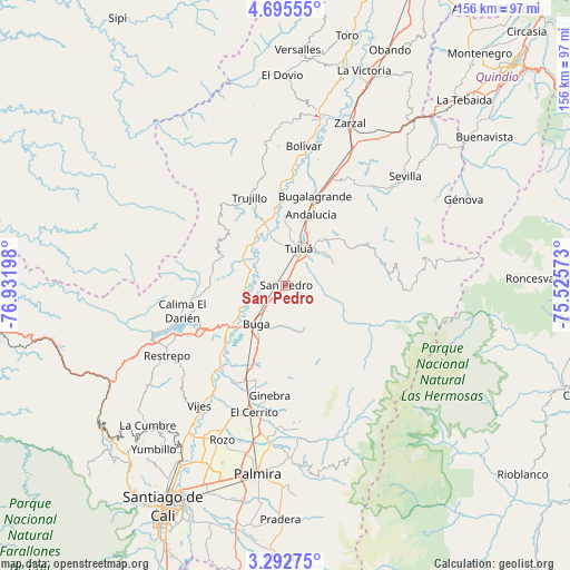
San Pedro GPS coordinates[2]
3° 59' 40.02" North, 76° 13' 43.86" West
| Map corner | latitude | longitude |
|---|---|---|
| Upper-left | 4.69555°, | -76.93198° |
| Center: | 3.99445°, | -76.22885° |
| Lower-right: | 3.29275°, | -75.52573° |
| Map W x H: | 156×156 km | = 96.9×96.9mi |
| max Lat: | 13.38166° ⇑78% North |
| San Pedro: | 3.99445° |
| min Lat: | ⇓22% South -4.21528° |
| min Long | San Pedro | max Long |
| -81.70636° | -76.22885° | -67.06996° |
| W 16.9%⇐ | ⇒83.1% E |
Elevation
Elevation of San Pedro is 988 m = 3241 ft, and this is 161.3 m = 529 ft below average elevation for this country.
| Max E: |
3342 m = 10965 ft | 54.3% |
| Avg. | 1149.3 m = 3771 ft | |
| San Pedro | 988 m = 3241 ft | |
Min E: |
1 m = 3 ft | 45.7% |
See also: Colombia elevation on elevation.city.
Geographical zone
San Pedro is located in North Torrid zone (between Equator and Tropic of Cancer). Distance of Equator is 444.1 km =276 mi to South.| Distance of | km | miles | from San Pedro |
|---|---|---|---|
| North Pole | 9562.9 | 5942.1 | to North |
| Arctic Circle | 6957 | 4322.9 | to North |
| Tropic Cancer | 2161.8 | 1343.3 | to North |
| Equator | 444.1 | 276 | to South |


Nearby cities:
15 places around San Pedro: (largest is in red/bold)
• Andalucía
20.8 km =12.9 mi,  19°
19°
• Bolívar
38.6 km =24 mi,  7°
7°
• Bugalagrande
25.5 km =15.8 mi, 18°
• Calimita
31.3 km =19.4 mi,  253°
253°
• Darien
29.2 km =18.1 mi,  256°
256°
• El Cerrito
35.6 km =22.1 mi,  195°
195°
• Ginebra
30.3 km =18.8 mi,  187°
187°
• Guacarí
28.1 km =17.5 mi, 204°
• Guadalajara de Buga
12.9 km =8 mi,  216°
216°
• La Cumbre
38 km =23.6 mi,  142°
142°
• Restrepo
37.8 km =23.5 mi,  239°
239°
• Riofrío
19.3 km =12 mi,  339°
339°
• Trujillo
26.2 km =16.3 mi, 337°
• Tuluá
10.7 km =6.6 mi, 20°
• Yotoco
22.7 km =14.1 mi,  229°
229°
Sources, notices
• [Note1] Compared only with cities in Colombia existing in our database
• [Src1] Map data: © OpenStreetMap contributors (CC-BY-SA)
• [Src2] Other city data from geonames.org with taken over terms of usage.
• [Src3] Geographical zone / Annual Mean Temperature by Robert A. Rohde @ Wikipedia
