Tuchín geodata
Tuchín (Córdoba) is a seat of a second-order administrative division; located in Colombia in America/Bogota (GMT-5) time zone. In our database, there are 1053 cities with bigger population. Compared to other cities in Colombia, 88% of cities are located further ↓South; 67.8% of cities are located further →East and 86.6% of cities have higher elevation than Tuchín. Note1


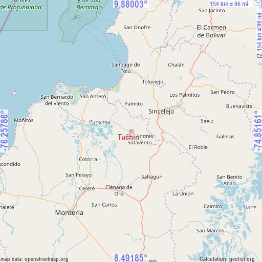
Tuchín GPS coordinates[2]
9° 11' 11.832" North, 75° 33' 17.028" West
| Map corner | latitude | longitude |
|---|---|---|
| Upper-left | 9.88003°, | -76.25786° |
| Center: | 9.18662°, | -75.55473° |
| Lower-right: | 8.49185°, | -74.85161° |
| Map W x H: | 154.4×154.4 km | = 95.9×95.9mi |
| max Lat: | 13.38166° ⇑12% North |
| Tuchín: | 9.18662° |
| min Lat: | ⇓88% South -4.21528° |
| min Long | Tuchín | max Long |
| -81.70636° | -75.55473° | -67.06996° |
| W 32.2%⇐ | ⇒67.8% E |
Elevation
Elevation of Tuchín is 49 m = 161 ft, and this is 1100.3 m = 3610 ft below average elevation for this country.
| Max E: |
3342 m = 10965 ft | 86.6% |
| Avg. | 1149.3 m = 3771 ft | |
| Tuchín | 49 m = 161 ft | |
Min E: |
1 m = 3 ft | 13.4% |
See also: Colombia elevation on elevation.city.
Geographical zone
Tuchín is located in North Torrid zone (between Equator and Tropic of Cancer). Distance of Equator is 1021.5 km =634.7 mi to South.| Distance of | km | miles | from Tuchín |
|---|---|---|---|
| North Pole | 8985.6 | 5583.4 | to North |
| Arctic Circle | 6379.7 | 3964.2 | to North |
| Tropic Cancer | 1584.5 | 984.6 | to North |
| Equator | 1021.5 | 634.7 | to South |


Nearby cities:
15 places around Tuchín: (largest is in red/bold)
• Chimá
9.1 km =5.7 mi,  242°
242°
• Chinú
19.4 km =12.1 mi,  117°
117°
• Cotorra
30.6 km =19 mi, 237°
• Coveñas
27.7 km =17.2 mi,  330°
330°
• Lorica
28.9 km =18 mi,  281°
281°
• Momil
14.4 km =8.9 mi,  293°
293°
• Morroa
31.9 km =19.8 mi,  59°
59°
• Palmito
16.2 km =10.1 mi,  5°
5°
• Purísima de la Concepción
19.2 km =11.9 mi, 286°
• Sahagún
29.4 km =18.3 mi,  155°
155°
• Sampués
19 km =11.8 mi,  91°
91°
• San Andrés de Sotavento
6.9 km =4.3 mi,  132°
132°
• San Antero
30.6 km =19 mi,  312°
312°
• Sincelejo
21.7 km =13.5 mi,  52°
52°
• Tolú Viejo
32 km =19.9 mi,  23°
23°
Sources, notices
• [Note1] Compared only with cities in Colombia existing in our database
• [Src1] Map data: © OpenStreetMap contributors (CC-BY-SA)
• [Src2] Other city data from geonames.org with taken over terms of usage.
• [Src3] Geographical zone / Annual Mean Temperature by Robert A. Rohde @ Wikipedia
