Sincelejo geodata
Sincelejo (Sucre) is a seat of a first-order administrative division; located in Colombia in America/Bogota (GMT-5) time zone. With population of 261,187 people, there are 21 cities with bigger population in this country. Compared to other cities in Colombia, 89.6% of cities are located further ↓South; 63.8% of cities are located further →East and 73.9% of cities have higher elevation than Sincelejo. Note1


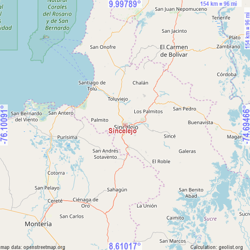
Sincelejo GPS coordinates[2]
9° 18' 16.992" North, 75° 23' 52.008" West
| Map corner | latitude | longitude |
|---|---|---|
| Upper-left | 9.99789°, | -76.10091° |
| Center: | 9.30472°, | -75.39778° |
| Lower-right: | 8.61017°, | -74.69466° |
| Map W x H: | 154.3×154.3 km | = 95.9×95.9mi |
| max Lat: | 13.38166° ⇑10.4% North |
| Sincelejo: | 9.30472° |
| min Lat: | ⇓89.6% South -4.21528° |
| min Long | Sincelejo | max Long |
| -81.70636° | -75.39778° | -67.06996° |
| W 36.2%⇐ | ⇒63.8% E |
Elevation
Elevation of Sincelejo is 211 m = 692 ft, and this is 938.3 m = 3078 ft below average elevation for this country.
| Max E: |
3342 m = 10965 ft | 73.9% |
| Avg. | 1149.3 m = 3771 ft | |
| Sincelejo | 211 m = 692 ft | |
Min E: |
1 m = 3 ft | 26.1% |
See also: Sincelejo elevation on elevation.city.
Geographical zone
Sincelejo is located in North Torrid zone (between Equator and Tropic of Cancer). Distance of Equator is 1034.6 km =642.9 mi to South.| Distance of | km | miles | from Sincelejo |
|---|---|---|---|
| North Pole | 8972.5 | 5575.3 | to North |
| Arctic Circle | 6366.6 | 3956 | to North |
| Tropic Cancer | 1571.3 | 976.4 | to North |
| Equator | 1034.6 | 642.9 | to South |


Nearby cities:
15 places around Sincelejo: (largest is in red/bold)
• Chalán
28.6 km =17.8 mi,  19°
19°
• Chimá
30.7 km =19.1 mi,  235°
235°
• Chinú
22.1 km =13.7 mi,  180°
180°
• Colosó
21.7 km =13.5 mi,  13°
13°
• Corozal
11.6 km =7.2 mi,  82°
82°
• Los Palmitos
16.5 km =10.3 mi,  59°
59°
• Morroa
10.6 km =6.6 mi,  72°
72°
• Ovejas
30.9 km =19.2 mi,  36°
36°
• Palmito
16.1 km =10 mi,  280°
280°
• Sampués
13.6 km =8.5 mi,  172°
172°
• San Andrés de Sotavento
21.6 km =13.4 mi,  214°
214°
• San Juan de Betulia
17.5 km =10.9 mi,  101°
101°
• San Luis de Sincé
28.4 km =17.6 mi, 103°
• Tolú Viejo
16.9 km =10.5 mi,  344°
344°
• Tuchín
21.7 km =13.5 mi,  232°
232°
Sources, notices
• [Note1] Compared only with cities in Colombia existing in our database
• [Src1] Map data: © OpenStreetMap contributors (CC-BY-SA)
• [Src2] Other city data from geonames.org with taken over terms of usage.
• [Src3] Geographical zone / Annual Mean Temperature by Robert A. Rohde @ Wikipedia
