Chinú geodata
Chinú (Córdoba) is a seat of a second-order administrative division; located in Colombia in America/Bogota (GMT-5) time zone. With population of 19,596 people, there are 185 cities with bigger population in this country. Compared to other cities in Colombia, 87.4% of cities are located further ↓South; 63.9% of cities are located further →East and 79.5% of cities have higher elevation than Chinú. Note1


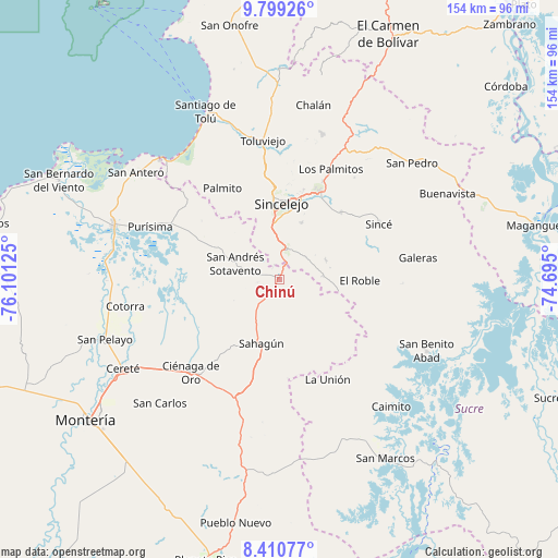
Chinú GPS coordinates[2]
9° 6' 20.484" North, 75° 23' 53.232" West
| Map corner | latitude | longitude |
|---|---|---|
| Upper-left | 9.79926°, | -76.10125° |
| Center: | 9.10569°, | -75.39812° |
| Lower-right: | 8.41077°, | -74.695° |
| Map W x H: | 154.4×154.4 km | = 95.9×95.9mi |
| max Lat: | 13.38166° ⇑12.6% North |
| Chinú: | 9.10569° |
| min Lat: | ⇓87.4% South -4.21528° |
| min Long | Chinú | max Long |
| -81.70636° | -75.39812° | -67.06996° |
| W 36.1%⇐ | ⇒63.9% E |
Elevation
Elevation of Chinú is 121 m = 397 ft, and this is 1028.3 m = 3374 ft below average elevation for this country.
| Max E: |
3342 m = 10965 ft | 79.5% |
| Avg. | 1149.3 m = 3771 ft | |
| Chinú | 121 m = 397 ft | |
Min E: |
1 m = 3 ft | 20.5% |
See also: Colombia elevation on elevation.city.
Geographical zone
Chinú is located in North Torrid zone (between Equator and Tropic of Cancer). Distance of Equator is 1012.5 km =629.1 mi to South.| Distance of | km | miles | from Chinú |
|---|---|---|---|
| North Pole | 8994.6 | 5589 | to North |
| Arctic Circle | 6388.7 | 3969.8 | to North |
| Tropic Cancer | 1593.5 | 990.2 | to North |
| Equator | 1012.5 | 629.1 | to South |


Nearby cities:
15 places around Chinú: (largest is in red/bold)
• Chimá
25.7 km =16 mi,  280°
280°
• Corozal
26.3 km =16.3 mi,  25°
25°
• El Roble
22.3 km =13.9 mi,  91°
91°
• La Unión
31.3 km =19.4 mi,  155°
155°
• Los Palmitos
33.6 km =20.9 mi, 25°
• Momil
33.7 km =20.9 mi,  295°
295°
• Morroa
27.3 km =17 mi,  21°
21°
• Palmito
29.7 km =18.5 mi,  327°
327°
• Sahagún
18.4 km =11.4 mi,  195°
195°
• Sampués
8.9 km =5.5 mi,  11°
11°
• San Andrés de Sotavento
12.9 km =8 mi,  289°
289°
• San Juan de Betulia
25.4 km =15.8 mi,  42°
42°
• San Luis de Sincé
31.6 km =19.6 mi,  60°
60°
• Sincelejo
22.1 km =13.7 mi,  0°
0°
• Tuchín
19.4 km =12.1 mi, 297°
Sources, notices
• [Note1] Compared only with cities in Colombia existing in our database
• [Src1] Map data: © OpenStreetMap contributors (CC-BY-SA)
• [Src2] Other city data from geonames.org with taken over terms of usage.
• [Src3] Geographical zone / Annual Mean Temperature by Robert A. Rohde @ Wikipedia
