Sibundoy geodata
Sibundoy (Putumayo) is a populated place; located in Colombia in America/Bogota (GMT-5) time zone. With population of 9,458 people, there are 325 cities with bigger population in this country. Compared to other cities in Colombia, 96.2% of cities are located further ↑North; 91.7% of cities are located further →East and 81% of cities have lower elevation than Sibundoy. Note1


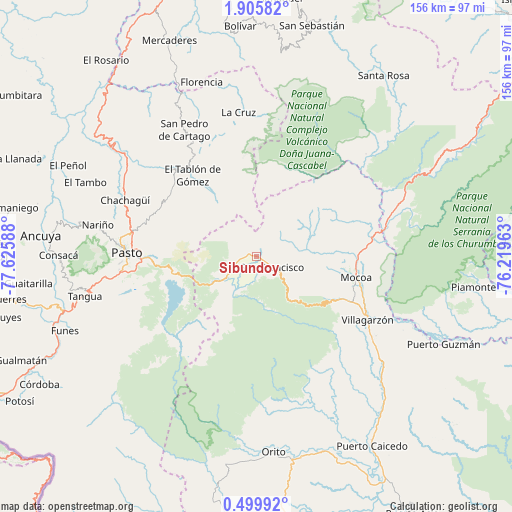
Sibundoy GPS coordinates[2]
1° 12' 10.656" North, 76° 55' 21.9" West
| Map corner | latitude | longitude |
|---|---|---|
| Upper-left | 1.90582°, | -77.62588° |
| Center: | 1.20296°, | -76.92275° |
| Lower-right: | 0.49992°, | -76.21963° |
| Map W x H: | 156.3×156.3 km | = 97.1×97.1mi |
| max Lat: | 13.38166° ⇑96.2% North |
| Sibundoy: | 1.20296° |
| min Lat: | ⇓3.8% South -4.21528° |
| min Long | Sibundoy | max Long |
| -81.70636° | -76.92275° | -67.06996° |
| W 8.3%⇐ | ⇒91.7% E |
Elevation
Elevation of Sibundoy is 2106 m = 6909 ft, and this is 956.7 m = 3139 ft above average elevation for this country.
| Max E: |
3342 m = 10965 ft | 19% |
| Sibundoy | 2106 m 6909 ft | |
| Avg. | 1149.3 m = 3771 ft | |
Min E: |
1 m = 3 ft | 81% |
See also: Colombia elevation on elevation.city.
Geographical zone
Sibundoy is located in North Torrid zone (between Equator and Tropic of Cancer). Distance of Equator is 133.8 km =83.1 mi to South.| Distance of | km | miles | from Sibundoy |
|---|---|---|---|
| North Pole | 9873.3 | 6135 | to North |
| Arctic Circle | 7267.4 | 4515.8 | to North |
| Tropic Cancer | 2472.2 | 1536.2 | to North |
| Equator | 133.8 | 83.1 | to South |


Nearby cities:
15 places around Sibundoy: (largest is in red/bold)
• Arboleda
40.4 km =25.1 mi,  324°
324°
• Buesaco
32.8 km =20.4 mi,  307°
307°
• Cartago
44.5 km =27.7 mi,  330°
330°
• Chachagüí
43.7 km =27.2 mi,  293°
293°
• Colón
5.8 km =3.6 mi,  256°
256°
• El Tablón
31.6 km =19.6 mi, 322°
• La Cruz
44.7 km =27.8 mi,  353°
353°
• Mocoa
30.6 km =19 mi,  100°
100°
• Pasto
39.9 km =24.8 mi,  271°
271°
• Puerres
38.2 km =23.7 mi, 268°
• San Bernardo
37.4 km =23.2 mi,  338°
338°
• San Francisco
5.7 km =3.5 mi,  120°
120°
• San José
35 km =21.7 mi, 329°
• Santiago
10.9 km =6.8 mi,  236°
236°
• Villagarzón
37.7 km =23.4 mi, 119°
Sources, notices
• [Note1] Compared only with cities in Colombia existing in our database
• [Src1] Map data: © OpenStreetMap contributors (CC-BY-SA)
• [Src2] Other city data from geonames.org with taken over terms of usage.
• [Src3] Geographical zone / Annual Mean Temperature by Robert A. Rohde @ Wikipedia
