Mocoa geodata
Mocoa (Putumayo) is a seat of a first-order administrative division; located in Colombia in America/Bogota (GMT-5) time zone. With population of 22,035 people, there are 166 cities with bigger population in this country. Compared to other cities in Colombia, 96.6% of cities are located further ↑North; 89.1% of cities are located further →East and 62% of cities have higher elevation than Mocoa. Note1


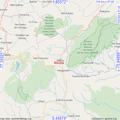
Mocoa GPS coordinates[2]
1° 9' 10.224" North, 76° 39' 7.488" West
| Map corner | latitude | longitude |
|---|---|---|
| Upper-left | 1.85572°, | -77.35521° |
| Center: | 1.15284°, | -76.65208° |
| Lower-right: | 0.44979°, | -75.94896° |
| Map W x H: | 156.3×156.3 km | = 97.1×97.1mi |
| max Lat: | 13.38166° ⇑96.6% North |
| Mocoa: | 1.15284° |
| min Lat: | ⇓3.4% South -4.21528° |
| min Long | Mocoa | max Long |
| -81.70636° | -76.65208° | -67.06996° |
| W 10.9%⇐ | ⇒89.1% E |
Elevation
Elevation of Mocoa is 612 m = 2008 ft, and this is 537.3 m = 1763 ft below average elevation for this country.
| Max E: |
3342 m = 10965 ft | 62% |
| Avg. | 1149.3 m = 3771 ft | |
| Mocoa | 612 m = 2008 ft | |
Min E: |
1 m = 3 ft | 38% |
See also: Colombia elevation on elevation.city.
Geographical zone
Mocoa is located in North Torrid zone (between Equator and Tropic of Cancer). Distance of Equator is 128.2 km =79.7 mi to South.| Distance of | km | miles | from Mocoa |
|---|---|---|---|
| North Pole | 9878.9 | 6138.5 | to North |
| Arctic Circle | 7273 | 4519.2 | to North |
| Tropic Cancer | 2477.7 | 1539.6 | to North |
| Equator | 128.2 | 79.7 | to South |


Nearby cities:
15 places around Mocoa: (largest is in red/bold)
• Buesaco
61.6 km =38.3 mi,  294°
294°
• Colón
36 km =22.4 mi,  276°
276°
• El Tablón
58.1 km =36.1 mi,  301°
301°
• La Cruz
61.3 km =38.1 mi,  324°
324°
• Orito
59.3 km =36.8 mi,  204°
204°
• Piamonte
37 km =23 mi,  95°
95°
• Puerto Caicedo
52.4 km =32.6 mi,  174°
174°
• Puerto Guzmán
21.6 km =13.4 mi,  160°
160°
• Puerto Guzmán
34.3 km =21.3 mi,  127°
127°
• San Bernardo
59.6 km =37 mi,  312°
312°
• San Francisco
25.3 km =15.7 mi, 275°
• San José
59.6 km =37 mi, 306°
• Santiago
39.2 km =24.4 mi,  269°
269°
• Sibundoy
30.6 km =19 mi, 280°
• Villagarzón
13.1 km =8.1 mi, 167°
Sources, notices
• [Note1] Compared only with cities in Colombia existing in our database
• [Src1] Map data: © OpenStreetMap contributors (CC-BY-SA)
• [Src2] Other city data from geonames.org with taken over terms of usage.
• [Src3] Geographical zone / Annual Mean Temperature by Robert A. Rohde @ Wikipedia
