Villagarzón geodata
Villagarzón (Putumayo) is a populated place; located in Colombia in America/Bogota (GMT-5) time zone. With population of 7,015 people, there are 408 cities with bigger population in this country. Compared to other cities in Colombia, 97.4% of cities are located further ↑North; 88.5% of cities are located further →East and 64.8% of cities have higher elevation than Villagarzón. Note1


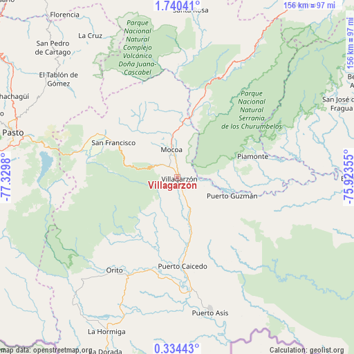
Villagarzón GPS coordinates[2]
1° 2' 15" North, 76° 37' 36.012" West
| Map corner | latitude | longitude |
|---|---|---|
| Upper-left | 1.74041°, | -77.3298° |
| Center: | 1.0375°, | -76.62667° |
| Lower-right: | 0.33443°, | -75.92355° |
| Map W x H: | 156.3×156.3 km | = 97.1×97.1mi |
| max Lat: | 13.38166° ⇑97.4% North |
| Villagarzón: | 1.0375° |
| min Lat: | ⇓2.6% South -4.21528° |
| min Long | Villagarzón | max Long |
| -81.70636° | -76.62667° | -67.06996° |
| W 11.5%⇐ | ⇒88.5% E |
Elevation
Elevation of Villagarzón is 446 m = 1463 ft, and this is 703.3 m = 2307 ft below average elevation for this country.
| Max E: |
3342 m = 10965 ft | 64.8% |
| Avg. | 1149.3 m = 3771 ft | |
| Villagarzón | 446 m = 1463 ft | |
Min E: |
1 m = 3 ft | 35.2% |
See also: Colombia elevation on elevation.city.
Geographical zone
Villagarzón is located in North Torrid zone (between Equator and Tropic of Cancer). Distance of Equator is 115.4 km =71.7 mi to South.| Distance of | km | miles | from Villagarzón |
|---|---|---|---|
| North Pole | 9891.7 | 6146.4 | to North |
| Arctic Circle | 7285.8 | 4527.2 | to North |
| Tropic Cancer | 2490.6 | 1547.6 | to North |
| Equator | 115.4 | 71.7 | to South |


Nearby cities:
15 places around Villagarzón: (largest is in red/bold)
• Buesaco
70.3 km =43.7 mi,  303°
303°
• Colón
42.2 km =26.2 mi,  293°
293°
• El Tablón
67.9 km =42.2 mi,  309°
309°
• Mocoa
13.1 km =8.1 mi,  347°
347°
• Orito
49.4 km =30.7 mi,  213°
213°
• Piamonte
35.2 km =21.9 mi,  74°
74°
• Puerto Asís
61 km =37.9 mi,  166°
166°
• Puerto Caicedo
39.4 km =24.5 mi,  176°
176°
• Puerto Guzmán
8.7 km =5.4 mi,  148°
148°
• Puerto Guzmán
25.6 km =15.9 mi,  108°
108°
• San Bernardo
70.7 km =43.9 mi,  318°
318°
• San Francisco
32 km =19.9 mi, 298°
• San José
70.1 km =43.6 mi, 313°
• Santiago
43.8 km =27.2 mi, 286°
• Sibundoy
37.7 km =23.4 mi, 299°
Sources, notices
• [Note1] Compared only with cities in Colombia existing in our database
• [Src1] Map data: © OpenStreetMap contributors (CC-BY-SA)
• [Src2] Other city data from geonames.org with taken over terms of usage.
• [Src3] Geographical zone / Annual Mean Temperature by Robert A. Rohde @ Wikipedia
