Andalucía geodata
Andalucía (Valle del Cauca) is a seat of a second-order administrative division; located in Colombia in America/Bogota (GMT-5) time zone. With population of 17,432 people, there are 202 cities with bigger population in this country. Compared to other cities in Colombia, 76.7% of cities are located further ↑North; 82.5% of cities are located further →East and 55.9% of cities have higher elevation than Andalucía. Note1


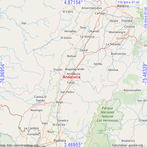
Andalucía GPS coordinates[2]
4° 10' 14.196" North, 76° 9' 59.076" West
| Map corner | latitude | longitude |
|---|---|---|
| Upper-left | 4.87154°, | -76.86954° |
| Center: | 4.17061°, | -76.16641° |
| Lower-right: | 3.46905°, | -75.46329° |
| Map W x H: | 155.9×155.9 km | = 96.9×96.9mi |
| max Lat: | 13.38166° ⇑76.7% North |
| Andalucía: | 4.17061° |
| min Lat: | ⇓23.3% South -4.21528° |
| min Long | Andalucía | max Long |
| -81.70636° | -76.16641° | -67.06996° |
| W 17.5%⇐ | ⇒82.5% E |
Elevation
Elevation of Andalucía is 958 m = 3143 ft, and this is 191.3 m = 628 ft below average elevation for this country.
| Max E: |
3342 m = 10965 ft | 55.9% |
| Avg. | 1149.3 m = 3771 ft | |
| Andalucía | 958 m = 3143 ft | |
Min E: |
1 m = 3 ft | 44.1% |
See also: Colombia elevation on elevation.city.
Geographical zone
Andalucía is located in North Torrid zone (between Equator and Tropic of Cancer). Distance of Equator is 463.7 km =288.1 mi to South.| Distance of | km | miles | from Andalucía |
|---|---|---|---|
| North Pole | 9543.3 | 5929.9 | to North |
| Arctic Circle | 6937.4 | 4310.7 | to North |
| Tropic Cancer | 2142.2 | 1331.1 | to North |
| Equator | 463.7 | 288.1 | to South |


Nearby cities:
15 places around Andalucía: (largest is in red/bold)
• Bolívar
18.8 km =11.7 mi,  354°
354°
• Bugalagrande
4.8 km =3 mi,  14°
14°
• Caicedonia
41.7 km =25.9 mi,  64°
64°
• El Dovio
38.3 km =23.8 mi, 348°
• Guadalajara de Buga
33.3 km =20.7 mi,  205°
205°
• Génova
42.1 km =26.2 mi,  84°
84°
• La Unión
40.9 km =25.4 mi, 9°
• La Victoria
41.8 km =26 mi,  19°
19°
• Riofrío
13.6 km =8.5 mi,  263°
263°
• Roldanillo
26.9 km =16.7 mi,  2°
2°
• San Pedro
20.8 km =12.9 mi,  199°
199°
• Sevilla
28.1 km =17.5 mi,  68°
68°
• Trujillo
17.6 km =10.9 mi,  285°
285°
• Tuluá
10.1 km =6.3 mi, 198°
• Zarzal
27 km =16.8 mi, 22°
Sources, notices
• [Note1] Compared only with cities in Colombia existing in our database
• [Src1] Map data: © OpenStreetMap contributors (CC-BY-SA)
• [Src2] Other city data from geonames.org with taken over terms of usage.
• [Src3] Geographical zone / Annual Mean Temperature by Robert A. Rohde @ Wikipedia
