Plato geodata
Plato (Magdalena) is a seat of a second-order administrative division; located in Colombia in America/Bogota (GMT-5) time zone. With population of 48,606 people, there are 85 cities with bigger population in this country. Compared to other cities in Colombia, 92% of cities are located further ↓South; 51% of cities are located further ←West and 91.2% of cities have higher elevation than Plato. Note1


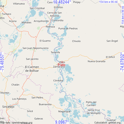
Plato GPS coordinates[2]
9° 47' 25.044" North, 74° 46' 56.784" West
| Map corner | latitude | longitude |
|---|---|---|
| Upper-left | 10.48244°, | -75.48557° |
| Center: | 9.79029°, | -74.78244° |
| Lower-right: | 9.0967°, | -74.07932° |
| Map W x H: | 154.1×154.1 km | = 95.8×95.8mi |
| max Lat: | 13.38166° ⇑8% North |
| Plato: | 9.79029° |
| min Lat: | ⇓92% South -4.21528° |
| min Long | Plato | max Long |
| -81.70636° | -74.78244° | -67.06996° |
| W 51%⇐ | ⇒49% E |
Elevation
Elevation of Plato is 25 m = 82 ft, and this is 1124.3 m = 3689 ft below average elevation for this country.
| Max E: |
3342 m = 10965 ft | 91.2% |
| Avg. | 1149.3 m = 3771 ft | |
| Plato | 25 m = 82 ft | |
Min E: |
1 m = 3 ft | 8.8% |
See also: Plato elevation on elevation.city.
Geographical zone
Plato is located in North Torrid zone (between Equator and Tropic of Cancer). Distance of Equator is 1088.6 km =676.4 mi to South.| Distance of | km | miles | from Plato |
|---|---|---|---|
| North Pole | 8918.5 | 5541.7 | to North |
| Arctic Circle | 6312.6 | 3922.5 | to North |
| Tropic Cancer | 1517.3 | 942.8 | to North |
| Equator | 1088.6 | 676.4 | to South |


Nearby cities:
15 places around Plato: (largest is in red/bold)
• Algarrobo
49.6 km =30.8 mi,  27°
27°
• Chivolo
31.4 km =19.5 mi, 33°
• Concordia
36.2 km =22.5 mi,  82°
82°
• Córdoba
23.2 km =14.4 mi,  192°
192°
• El Carmen de Bolívar
37.9 km =23.5 mi,  257°
257°
• El Guamo
34.2 km =21.3 mi,  321°
321°
• Nueva Granada
42.7 km =26.5 mi,  88°
88°
• Pedraza
46.5 km =28.9 mi,  341°
341°
• Punta de Piedras
42.7 km =26.5 mi,  9°
9°
• San Antonio
18.6 km =11.6 mi, 31°
• San Jacinto
37.4 km =23.2 mi,  276°
276°
• San Juan Nepomuceno
37.4 km =23.2 mi,  298°
298°
• Santa Bárbara de Pinto
40.7 km =25.3 mi,  167°
167°
• Tenerife
14.9 km =9.3 mi,  325°
325°
• Zambrano
6 km =3.7 mi,  217°
217°
Sources, notices
• [Note1] Compared only with cities in Colombia existing in our database
• [Src1] Map data: © OpenStreetMap contributors (CC-BY-SA)
• [Src2] Other city data from geonames.org with taken over terms of usage.
• [Src3] Geographical zone / Annual Mean Temperature by Robert A. Rohde @ Wikipedia
