San Juan Nepomuceno geodata
San Juan Nepomuceno (Bolívar) is a seat of a second-order administrative division; located in Colombia in America/Bogota (GMT-5) time zone. With population of 29,619 people, there are 122 cities with bigger population in this country. Compared to other cities in Colombia, 92.6% of cities are located further ↓South; 55.9% of cities are located further →East and 75.9% of cities have higher elevation than San Juan Nepomuceno. Note1


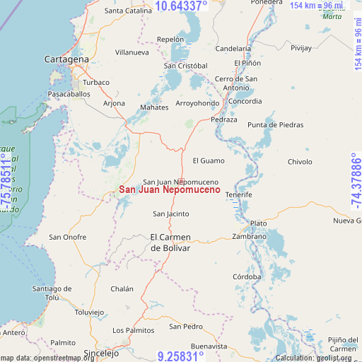
San Juan Nepomuceno GPS coordinates[2]
9° 57' 5.652" North, 75° 4' 55.128" West
| Map corner | latitude | longitude |
|---|---|---|
| Upper-left | 10.64337°, | -75.78511° |
| Center: | 9.95157°, | -75.08198° |
| Lower-right: | 9.25831°, | -74.37886° |
| Map W x H: | 154×154 km | = 95.7×95.7mi |
| max Lat: | 13.38166° ⇑7.4% North |
| San Juan Nepomuceno: | 9.95157° |
| min Lat: | ⇓92.6% South -4.21528° |
| min Long | San Juan Nepomu | max Long |
| -81.70636° | -75.08198° | -67.06996° |
| W 44.1%⇐ | ⇒55.9% E |
Elevation
Elevation of San Juan Nepomuceno is 172 m = 564 ft, and this is 977.3 m = 3206 ft below average elevation for this country.
| Max E: |
3342 m = 10965 ft | 75.9% |
| Avg. | 1149.3 m = 3771 ft | |
| San Juan Nepomuceno | 172 m = 564 ft | |
Min E: |
1 m = 3 ft | 24.1% |
See also: Colombia elevation on elevation.city.
Geographical zone
San Juan Nepomuceno is located in North Torrid zone (between Equator and Tropic of Cancer). Distance of Equator is 1106.5 km =687.5 mi to South.| Distance of | km | miles | from San Juan Nepomuceno |
|---|---|---|---|
| North Pole | 8900.6 | 5530.6 | to North |
| Arctic Circle | 6294.7 | 3911.3 | to North |
| Tropic Cancer | 1499.4 | 931.7 | to North |
| Equator | 1106.5 | 687.5 | to South |


Nearby cities:
15 places around San Juan Nepomuceno: (largest is in red/bold)
• Arroyohondo
34.1 km =21.2 mi,  11°
11°
• Calamar
38.1 km =23.7 mi,  28°
28°
• El Carmen de Bolívar
26.4 km =16.4 mi,  189°
189°
• El Guamo
14.6 km =9.1 mi,  52°
52°
• Mahates
33.4 km =20.8 mi,  339°
339°
• María la Baja
24.3 km =15.1 mi,  278°
278°
• Pedraza
32 km =19.9 mi, 34°
• Plato
37.4 km =23.2 mi,  118°
118°
• San Antonio
42.6 km =26.5 mi,  92°
92°
• San Cristóbal
20.4 km =12.7 mi,  246°
246°
• San Jacinto
14.4 km =8.9 mi,  197°
197°
• San Pablo
23.2 km =14.4 mi,  298°
298°
• Santa Lucía
43.5 km =27 mi,  17°
17°
• Tenerife
25 km =15.5 mi,  103°
103°
• Zambrano
37 km =23 mi,  127°
127°
Sources, notices
• [Note1] Compared only with cities in Colombia existing in our database
• [Src1] Map data: © OpenStreetMap contributors (CC-BY-SA)
• [Src2] Other city data from geonames.org with taken over terms of usage.
• [Src3] Geographical zone / Annual Mean Temperature by Robert A. Rohde @ Wikipedia
