Salgar geodata
Salgar (Antioquia) is a seat of a second-order administrative division; located in Colombia in America/Bogota (GMT-5) time zone. With population of 6,428 people, there are 426 cities with bigger population in this country. Compared to other cities in Colombia, 58.7% of cities are located further ↓South; 79.3% of cities are located further →East and 52.4% of cities have lower elevation than Salgar. Note1


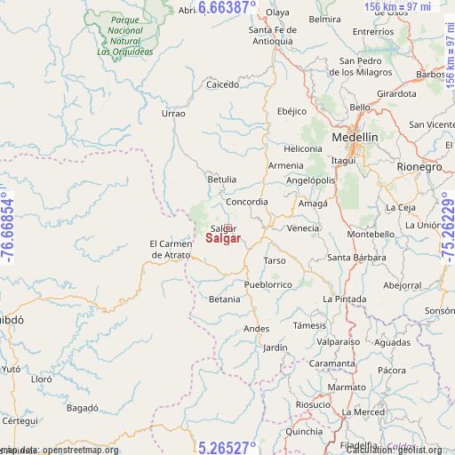
Salgar GPS coordinates[2]
5° 57' 54.072" North, 75° 57' 55.476" West
| Map corner | latitude | longitude |
|---|---|---|
| Upper-left | 6.66387°, | -76.66854° |
| Center: | 5.96502°, | -75.96541° |
| Lower-right: | 5.26527°, | -75.26229° |
| Map W x H: | 155.5×155.5 km | = 96.6×96.6mi |
| max Lat: | 13.38166° ⇑41.3% North |
| Salgar: | 5.96502° |
| min Lat: | ⇓58.7% South -4.21528° |
| min Long | Salgar | max Long |
| -81.70636° | -75.96541° | -67.06996° |
| W 20.7%⇐ | ⇒79.3% E |
Elevation
Elevation of Salgar is 1209 m = 3967 ft, and this is 59.7 m = 196 ft above average elevation for this country.
| Max E: |
3342 m = 10965 ft | 47.6% |
| Salgar | 1209 m 3967 ft | |
| Avg. | 1149.3 m = 3771 ft | |
Min E: |
1 m = 3 ft | 52.4% |
See also: Colombia elevation on elevation.city.
Geographical zone
Salgar is located in North Torrid zone (between Equator and Tropic of Cancer). Distance of Equator is 663.2 km =412.1 mi to South.| Distance of | km | miles | from Salgar |
|---|---|---|---|
| North Pole | 9343.8 | 5806 | to North |
| Arctic Circle | 6737.9 | 4186.7 | to North |
| Tropic Cancer | 1942.7 | 1207.1 | to North |
| Equator | 663.2 | 412.1 | to South |


Nearby cities:
15 places around Salgar: (largest is in red/bold)
• Amagá
30.2 km =18.8 mi,  73°
73°
• Angelópolis
32.6 km =20.3 mi,  60°
60°
• Armenia
29 km =18 mi,  42°
42°
• Betania
24.4 km =15.2 mi,  183°
183°
• Betulia
16.6 km =10.3 mi,  352°
352°
• Ciudad Bolívar
14 km =8.7 mi,  208°
208°
• Concordia
11.1 km =6.9 mi, 35°
• El Carmen de Atrato
20.9 km =13 mi,  249°
249°
• Hispania
19.5 km =12.1 mi,  160°
160°
• Jericó
27.6 km =17.1 mi,  134°
134°
• Pueblorrico
23.7 km =14.7 mi,  144°
144°
• San Francisco
17 km =10.6 mi, 353°
• Tarso
19.4 km =12.1 mi, 125°
• Titiribí
21.9 km =13.6 mi, 60°
• Venecia
25.1 km =15.6 mi,  90°
90°
Sources, notices
• [Note1] Compared only with cities in Colombia existing in our database
• [Src1] Map data: © OpenStreetMap contributors (CC-BY-SA)
• [Src2] Other city data from geonames.org with taken over terms of usage.
• [Src3] Geographical zone / Annual Mean Temperature by Robert A. Rohde @ Wikipedia
