Venecia geodata
Venecia (Antioquia) is a seat of a second-order administrative division; located in Colombia in America/Bogota (GMT-5) time zone. With population of 5,462 people, there are 476 cities with bigger population in this country. Compared to other cities in Colombia, 58.5% of cities are located further ↓South; 73.4% of cities are located further →East and 55.5% of cities have lower elevation than Venecia. Note1


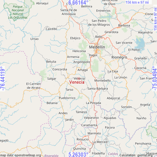
Venecia GPS coordinates[2]
5° 57' 46.008" North, 75° 44' 17.016" West
| Map corner | latitude | longitude |
|---|---|---|
| Upper-left | 6.66164°, | -76.44119° |
| Center: | 5.96278°, | -75.73806° |
| Lower-right: | 5.26303°, | -75.03494° |
| Map W x H: | 155.5×155.5 km | = 96.6×96.6mi |
| max Lat: | 13.38166° ⇑41.5% North |
| Venecia: | 5.96278° |
| min Lat: | ⇓58.5% South -4.21528° |
| min Long | Venecia | max Long |
| -81.70636° | -75.73806° | -67.06996° |
| W 26.6%⇐ | ⇒73.4% E |
Elevation
Elevation of Venecia is 1308 m = 4291 ft, and this is 158.7 m = 521 ft above average elevation for this country.
| Max E: |
3342 m = 10965 ft | 44.5% |
| Venecia | 1308 m 4291 ft | |
| Avg. | 1149.3 m = 3771 ft | |
Min E: |
1 m = 3 ft | 55.5% |
See also: Colombia elevation on elevation.city.
Geographical zone
Venecia is located in North Torrid zone (between Equator and Tropic of Cancer). Distance of Equator is 663 km =412 mi to South.| Distance of | km | miles | from Venecia |
|---|---|---|---|
| North Pole | 9344.1 | 5806.2 | to North |
| Arctic Circle | 6738.2 | 4186.9 | to North |
| Tropic Cancer | 1942.9 | 1207.3 | to North |
| Equator | 663 | 412 | to South |


Nearby cities:
15 places around Venecia: (largest is in red/bold)
• Amagá
9.4 km =5.8 mi,  24°
24°
• Angelópolis
16.8 km =10.4 mi,  10°
10°
• Armenia
22.2 km =13.8 mi,  345°
345°
• Caldas
18.2 km =11.3 mi,  38°
38°
• Concordia
20.9 km =13 mi,  296°
296°
• Fredonia
8.5 km =5.3 mi,  118°
118°
• Jericó
19.7 km =12.2 mi,  195°
195°
• La Estrella
24.1 km =15 mi,  25°
25°
• Montebello
23.3 km =14.5 mi,  94°
94°
• Pueblorrico
22.2 km =13.8 mi,  210°
210°
• Sabaneta
24.9 km =15.5 mi, 32°
• Salgar
25.1 km =15.6 mi,  270°
270°
• Santa Bárbara
21.3 km =13.2 mi, 117°
• Tarso
14.3 km =8.9 mi,  220°
220°
• Titiribí
12.7 km =7.9 mi,  331°
331°
Sources, notices
• [Note1] Compared only with cities in Colombia existing in our database
• [Src1] Map data: © OpenStreetMap contributors (CC-BY-SA)
• [Src2] Other city data from geonames.org with taken over terms of usage.
• [Src3] Geographical zone / Annual Mean Temperature by Robert A. Rohde @ Wikipedia
