Amagá geodata
Amagá (Antioquia) is a seat of a second-order administrative division; located in Colombia in America/Bogota (GMT-5) time zone. With population of 12,170 people, there are 254 cities with bigger population in this country. Compared to other cities in Colombia, 60% of cities are located further ↓South; 72.1% of cities are located further →East and 57.2% of cities have lower elevation than Amagá. Note1


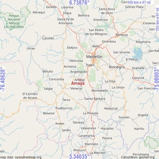
Amagá GPS coordinates[2]
6° 2' 24.036" North, 75° 42' 11.34" West
| Map corner | latitude | longitude |
|---|---|---|
| Upper-left | 6.73876°, | -76.40628° |
| Center: | 6.04001°, | -75.70315° |
| Lower-right: | 5.34035°, | -75.00003° |
| Map W x H: | 155.5×155.5 km | = 96.6×96.6mi |
| max Lat: | 13.38166° ⇑40% North |
| Amagá: | 6.04001° |
| min Lat: | ⇓60% South -4.21528° |
| min Long | Amagá | max Long |
| -81.70636° | -75.70315° | -67.06996° |
| W 27.9%⇐ | ⇒72.1% E |
Elevation
Elevation of Amagá is 1370 m = 4495 ft, and this is 220.7 m = 724 ft above average elevation for this country.
| Max E: |
3342 m = 10965 ft | 42.8% |
| Amagá | 1370 m 4495 ft | |
| Avg. | 1149.3 m = 3771 ft | |
Min E: |
1 m = 3 ft | 57.2% |
See also: Colombia elevation on elevation.city.
Geographical zone
Amagá is located in North Torrid zone (between Equator and Tropic of Cancer). Distance of Equator is 671.6 km =417.3 mi to South.| Distance of | km | miles | from Amagá |
|---|---|---|---|
| North Pole | 9335.5 | 5800.8 | to North |
| Arctic Circle | 6729.6 | 4181.6 | to North |
| Tropic Cancer | 1934.3 | 1201.9 | to North |
| Equator | 671.6 | 417.3 | to South |


Nearby cities:
15 places around Amagá: (largest is in red/bold)
• Angelópolis
7.9 km =4.9 mi,  355°
355°
• Armenia
15.9 km =9.9 mi,  324°
324°
• Caldas
9.4 km =5.8 mi,  52°
52°
• Concordia
22.6 km =14 mi,  271°
271°
• Envigado
19.5 km =12.1 mi,  39°
39°
• Fredonia
13.2 km =8.2 mi,  164°
164°
• Heliconia
19.1 km =11.9 mi,  349°
349°
• Itagüí
19.8 km =12.3 mi, 35°
• La Estrella
14.7 km =9.1 mi,  26°
26°
• Montebello
22 km =13.7 mi,  117°
117°
• Retiro
22.2 km =13.8 mi,  84°
84°
• Sabaneta
15.7 km =9.8 mi, 37°
• Tarso
23.5 km =14.6 mi,  213°
213°
• Titiribí
10.3 km =6.4 mi,  284°
284°
• Venecia
9.4 km =5.8 mi,  204°
204°
Sources, notices
• [Note1] Compared only with cities in Colombia existing in our database
• [Src1] Map data: © OpenStreetMap contributors (CC-BY-SA)
• [Src2] Other city data from geonames.org with taken over terms of usage.
• [Src3] Geographical zone / Annual Mean Temperature by Robert A. Rohde @ Wikipedia
