Angelópolis geodata
Angelópolis (Antioquia) is a seat of a second-order administrative division; located in Colombia in America/Bogota (GMT-5) time zone. With population of 1,917 people, there are 810 cities with bigger population in this country. Compared to other cities in Colombia, 61.2% of cities are located further ↓South; 72.5% of cities are located further →East and 76.3% of cities have lower elevation than Angelópolis. Note1


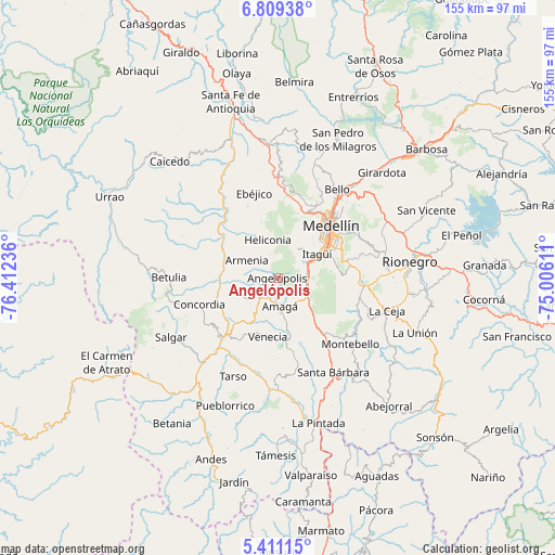
Angelópolis GPS coordinates[2]
6° 6' 38.592" North, 75° 42' 33.228" West
| Map corner | latitude | longitude |
|---|---|---|
| Upper-left | 6.80938°, | -76.41236° |
| Center: | 6.11072°, | -75.70923° |
| Lower-right: | 5.41115°, | -75.00611° |
| Map W x H: | 155.5×155.5 km | = 96.6×96.6mi |
| max Lat: | 13.38166° ⇑38.8% North |
| Angelópolis: | 6.11072° |
| min Lat: | ⇓61.2% South -4.21528° |
| min Long | Angelópolis | max Long |
| -81.70636° | -75.70923° | -67.06996° |
| W 27.5%⇐ | ⇒72.5% E |
Elevation
Elevation of Angelópolis is 1898 m = 6227 ft, and this is 748.7 m = 2456 ft above average elevation for this country.
| Max E: |
3342 m = 10965 ft | 23.7% |
| Angelópolis | 1898 m 6227 ft | |
| Avg. | 1149.3 m = 3771 ft | |
Min E: |
1 m = 3 ft | 76.3% |
See also: Colombia elevation on elevation.city.
Geographical zone
Angelópolis is located in North Torrid zone (between Equator and Tropic of Cancer). Distance of Equator is 679.4 km =422.2 mi to South.| Distance of | km | miles | from Angelópolis |
|---|---|---|---|
| North Pole | 9327.6 | 5795.9 | to North |
| Arctic Circle | 6721.7 | 4176.7 | to North |
| Tropic Cancer | 1926.5 | 1197.1 | to North |
| Equator | 679.4 | 422.2 | to South |


Nearby cities:
15 places around Angelópolis: (largest is in red/bold)
• Amagá
7.9 km =4.9 mi,  175°
175°
• Armenia
10 km =6.2 mi,  300°
300°
• Caldas
8.4 km =5.2 mi,  105°
105°
• Concordia
23 km =14.3 mi,  251°
251°
• Ebéjico
24.8 km =15.4 mi,  344°
344°
• Envigado
14.9 km =9.3 mi,  60°
60°
• Fredonia
21 km =13 mi,  168°
168°
• Heliconia
11.2 km =7 mi, 344°
• Itagüí
14.7 km =9.1 mi, 55°
• La Estrella
9 km =5.6 mi,  54°
54°
• Medellín
22.5 km =14 mi, 45°
• Retiro
23.5 km =14.6 mi,  104°
104°
• Sabaneta
11.2 km =7 mi,  66°
66°
• Titiribí
10.8 km =6.7 mi,  240°
240°
• Venecia
16.8 km =10.4 mi,  190°
190°
Sources, notices
• [Note1] Compared only with cities in Colombia existing in our database
• [Src1] Map data: © OpenStreetMap contributors (CC-BY-SA)
• [Src2] Other city data from geonames.org with taken over terms of usage.
• [Src3] Geographical zone / Annual Mean Temperature by Robert A. Rohde @ Wikipedia
