Pueblo Rico geodata
Pueblo Rico (Risaralda) is a seat of a second-order administrative division; located in Colombia in America/Bogota (GMT-5) time zone. With population of 4,165 people, there are 565 cities with bigger population in this country. Compared to other cities in Colombia, 56.7% of cities are located further ↑North; 80.7% of cities are located further →East and 94.1% of cities have lower elevation than Pueblo Rico. Note1


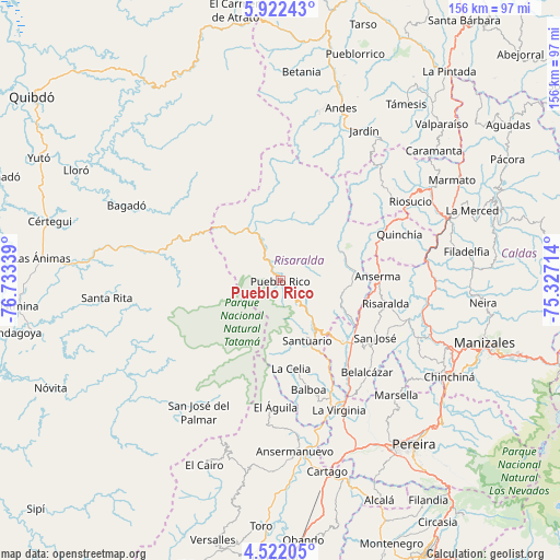
Pueblo Rico GPS coordinates[2]
5° 13' 21.468" North, 76° 1' 48.936" West
| Map corner | latitude | longitude |
|---|---|---|
| Upper-left | 5.92243°, | -76.73339° |
| Center: | 5.22263°, | -76.03026° |
| Lower-right: | 4.52205°, | -75.32714° |
| Map W x H: | 155.7×155.7 km | = 96.7×96.7mi |
| max Lat: | 13.38166° ⇑56.7% North |
| Pueblo Rico: | 5.22263° |
| min Lat: | ⇓43.3% South -4.21528° |
| min Long | Pueblo Rico | max Long |
| -81.70636° | -76.03026° | -67.06996° |
| W 19.3%⇐ | ⇒80.7% E |
Elevation
Elevation of Pueblo Rico is 2636 m = 8648 ft, and this is 1486.7 m = 4878 ft above average elevation for this country.
| Max E: |
3342 m = 10965 ft | 5.9% |
| Pueblo Rico | 2636 m 8648 ft | |
| Avg. | 1149.3 m = 3771 ft | |
Min E: |
1 m = 3 ft | 94.1% |
See also: Colombia elevation on elevation.city.
Geographical zone
Pueblo Rico is located in North Torrid zone (between Equator and Tropic of Cancer). Distance of Equator is 580.7 km =360.8 mi to South.| Distance of | km | miles | from Pueblo Rico |
|---|---|---|---|
| North Pole | 9426.4 | 5857.3 | to North |
| Arctic Circle | 6820.5 | 4238.1 | to North |
| Tropic Cancer | 2025.2 | 1258.4 | to North |
| Equator | 580.7 | 360.8 | to South |


Nearby cities:
15 places around Pueblo Rico: (largest is in red/bold)
• Anserma
27.2 km =16.9 mi,  87°
87°
• Anserma
29.2 km =18.1 mi,  65°
65°
• Apía
16.2 km =10.1 mi,  142°
142°
• Balboa
31.4 km =19.5 mi,  165°
165°
• Belalcázar
34.9 km =21.7 mi, 136°
• Belén de Umbría
18.1 km =11.2 mi,  97°
97°
• El Águila
34.4 km =21.4 mi,  181°
181°
• Guática
27.7 km =17.2 mi, 68°
• La Celia
24.6 km =15.3 mi, 173°
• La Merced
25.6 km =15.9 mi,  38°
38°
• Mistrató
18.2 km =11.3 mi,  63°
63°
• Risaralda
29.9 km =18.6 mi, 102°
• San José
30.7 km =19.1 mi,  120°
120°
• Santuario
18.1 km =11.2 mi,  156°
156°
• Viterbo
25 km =15.5 mi, 135°
Sources, notices
• [Note1] Compared only with cities in Colombia existing in our database
• [Src1] Map data: © OpenStreetMap contributors (CC-BY-SA)
• [Src2] Other city data from geonames.org with taken over terms of usage.
• [Src3] Geographical zone / Annual Mean Temperature by Robert A. Rohde @ Wikipedia
