San José geodata
San José (Caldas) is a seat of a second-order administrative division; located in Colombia in America/Bogota (GMT-5) time zone. With population of 1,724 people, there are 832 cities with bigger population in this country. Compared to other cities in Colombia, 59.8% of cities are located further ↑North; 75.4% of cities are located further →East and 61% of cities have lower elevation than San José. Note1


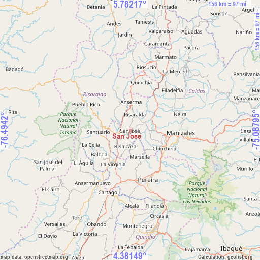
San José GPS coordinates[2]
5° 4' 55.956" North, 75° 47' 27.852" West
| Map corner | latitude | longitude |
|---|---|---|
| Upper-left | 5.78217°, | -76.4942° |
| Center: | 5.08221°, | -75.79107° |
| Lower-right: | 4.38149°, | -75.08795° |
| Map W x H: | 155.7×155.7 km | = 96.7×96.7mi |
| max Lat: | 13.38166° ⇑59.8% North |
| San José: | 5.08221° |
| min Lat: | ⇓40.2% South -4.21528° |
| min Long | San José | max Long |
| -81.70636° | -75.79107° | -67.06996° |
| W 24.6%⇐ | ⇒75.4% E |
Elevation
Elevation of San José is 1491 m = 4892 ft, and this is 341.7 m = 1121 ft above average elevation for this country.
| Max E: |
3342 m = 10965 ft | 39% |
| San José | 1491 m 4892 ft | |
| Avg. | 1149.3 m = 3771 ft | |
Min E: |
1 m = 3 ft | 61% |
See also: Colombia elevation on elevation.city.
Geographical zone
San José is located in North Torrid zone (between Equator and Tropic of Cancer). Distance of Equator is 565.1 km =351.1 mi to South.| Distance of | km | miles | from San José |
|---|---|---|---|
| North Pole | 9442 | 5867 | to North |
| Arctic Circle | 6836.1 | 4247.8 | to North |
| Tropic Cancer | 2040.8 | 1268.1 | to North |
| Equator | 565.1 | 351.1 | to South |


Nearby cities:
15 places around San José: (largest is in red/bold)
• Anserma
17 km =10.6 mi,  2°
2°
• Apía
17 km =10.6 mi,  279°
279°
• Balboa
23.7 km =14.7 mi,  231°
231°
• Belalcázar
10 km =6.2 mi,  193°
193°
• Belén de Umbría
15.7 km =9.8 mi,  326°
326°
• Chinchiná
23.5 km =14.6 mi,  118°
118°
• Guática
26 km =16.2 mi,  358°
358°
• La Celia
25.1 km =15.6 mi,  249°
249°
• La Virginia
22.7 km =14.1 mi,  206°
206°
• Marsella
17.2 km =10.7 mi,  159°
159°
• Mistrató
25.9 km =16.1 mi,  336°
336°
• Palestina
19.4 km =12.1 mi,  112°
112°
• Risaralda
9.8 km =6.1 mi,  16°
16°
• Santuario
19.2 km =11.9 mi,  267°
267°
• Viterbo
9.2 km =5.7 mi,  256°
256°
Sources, notices
• [Note1] Compared only with cities in Colombia existing in our database
• [Src1] Map data: © OpenStreetMap contributors (CC-BY-SA)
• [Src2] Other city data from geonames.org with taken over terms of usage.
• [Src3] Geographical zone / Annual Mean Temperature by Robert A. Rohde @ Wikipedia
