Guática geodata
Guática (Risaralda) is a seat of a second-order administrative division; located in Colombia in America/Bogota (GMT-5) time zone. With population of 4,368 people, there are 550 cities with bigger population in this country. Compared to other cities in Colombia, 54.6% of cities are located further ↑North; 75.7% of cities are located further →East and 76.9% of cities have lower elevation than Guática. Note1


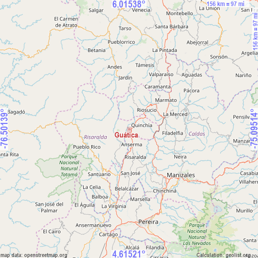
Guática GPS coordinates[2]
5° 18' 56.484" North, 75° 47' 53.736" West
| Map corner | latitude | longitude |
|---|---|---|
| Upper-left | 6.01538°, | -76.50139° |
| Center: | 5.31569°, | -75.79826° |
| Lower-right: | 4.61521°, | -75.09514° |
| Map W x H: | 155.7×155.7 km | = 96.7×96.7mi |
| max Lat: | 13.38166° ⇑54.6% North |
| Guática: | 5.31569° |
| min Lat: | ⇓45.4% South -4.21528° |
| min Long | Guática | max Long |
| -81.70636° | -75.79826° | -67.06996° |
| W 24.3%⇐ | ⇒75.7% E |
Elevation
Elevation of Guática is 1916 m = 6286 ft, and this is 766.7 m = 2515 ft above average elevation for this country.
| Max E: |
3342 m = 10965 ft | 23.1% |
| Guática | 1916 m 6286 ft | |
| Avg. | 1149.3 m = 3771 ft | |
Min E: |
1 m = 3 ft | 76.9% |
See also: Colombia elevation on elevation.city.
Geographical zone
Guática is located in North Torrid zone (between Equator and Tropic of Cancer). Distance of Equator is 591 km =367.2 mi to South.| Distance of | km | miles | from Guática |
|---|---|---|---|
| North Pole | 9416 | 5850.8 | to North |
| Arctic Circle | 6810.1 | 4231.6 | to North |
| Tropic Cancer | 2014.9 | 1252 | to North |
| Equator | 591 | 367.2 | to South |


Nearby cities:
15 places around Guática: (largest is in red/bold)
• Anserma
2.1 km =1.3 mi,  22°
22°
• Anserma
9.1 km =5.7 mi,  170°
170°
• Apía
28.2 km =17.5 mi,  214°
214°
• Belén de Umbría
15 km =9.3 mi, 211°
• Filadelfia
26.3 km =16.3 mi,  94°
94°
• La Merced
13.5 km =8.4 mi,  315°
315°
• La Merced
29.3 km =18.2 mi,  71°
71°
• Marmato
28.2 km =17.5 mi,  51°
51°
• Mistrató
9.7 km =6 mi,  257°
257°
• Pueblo Rico
27.7 km =17.2 mi,  248°
248°
• Quinchía
8 km =5 mi, 70°
• Riosucio
15.8 km =9.8 mi,  41°
41°
• Risaralda
17 km =10.6 mi, 167°
• San José
26 km =16.2 mi,  178°
178°
• Supía
22.4 km =13.9 mi, 46°
Sources, notices
• [Note1] Compared only with cities in Colombia existing in our database
• [Src1] Map data: © OpenStreetMap contributors (CC-BY-SA)
• [Src2] Other city data from geonames.org with taken over terms of usage.
• [Src3] Geographical zone / Annual Mean Temperature by Robert A. Rohde @ Wikipedia
