Potosí geodata
Potosí (Nariño) is a seat of a second-order administrative division; located in Colombia in America/Bogota (GMT-5) time zone. With population of 3,979 people, there are 585 cities with bigger population in this country. Compared to other cities in Colombia, 99.1% of cities are located further ↑North; 97.3% of cities are located further →East and 96.5% of cities have lower elevation than Potosí. Note1


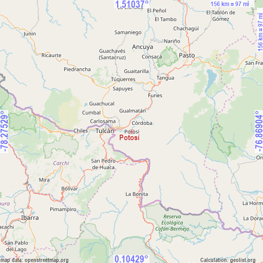
Potosí GPS coordinates[2]
0° 48' 26.604" North, 77° 34' 19.776" West
| Map corner | latitude | longitude |
|---|---|---|
| Upper-left | 1.51037°, | -78.27529° |
| Center: | 0.80739°, | -77.57216° |
| Lower-right: | 0.10429°, | -76.86904° |
| Map W x H: | 156.3×156.3 km | = 97.1×97.1mi |
| max Lat: | 13.38166° ⇑99.1% North |
| Potosí: | 0.80739° |
| min Lat: | ⇓0.9% South -4.21528° |
| min Long | Potosí | max Long |
| -81.70636° | -77.57216° | -67.06996° |
| W 2.7%⇐ | ⇒97.3% E |
Elevation
Elevation of Potosí is 2742 m = 8996 ft, and this is 1592.7 m = 5225 ft above average elevation for this country.
| Max E: |
3342 m = 10965 ft | 3.5% |
| Potosí | 2742 m 8996 ft | |
| Avg. | 1149.3 m = 3771 ft | |
Min E: |
1 m = 3 ft | 96.5% |
See also: Colombia elevation on elevation.city.
Geographical zone
Potosí is located in North Torrid zone (between Equator and Tropic of Cancer). Distance of Equator is 89.8 km =55.8 mi to South.| Distance of | km | miles | from Potosí |
|---|---|---|---|
| North Pole | 9917.3 | 6162.3 | to North |
| Arctic Circle | 7311.4 | 4543.1 | to North |
| Tropic Cancer | 2516.1 | 1563.4 | to North |
| Equator | 89.8 | 55.8 | to South |


Nearby cities:
15 places around Potosí: (largest is in red/bold)
• Aldana
16.6 km =10.3 mi,  300°
300°
• Carlosama
18.3 km =11.4 mi,  289°
289°
• Contadero
11.6 km =7.2 mi,  13°
13°
• Cumbal
26.9 km =16.7 mi, 294°
• Córdoba
7.9 km =4.9 mi,  49°
49°
• Funes
25.5 km =15.8 mi,  32°
32°
• Guachucal
24.6 km =15.3 mi,  313°
313°
• Gualmatán
12.5 km =7.8 mi,  2°
2°
• Iles
19 km =11.8 mi,  17°
17°
• Imués
28.8 km =17.9 mi, 16°
• Ipiales
7.8 km =4.8 mi,  284°
284°
• Ospina
28 km =17.4 mi, 1°
• Puerres
11.4 km =7.1 mi,  42°
42°
• Pupiales
10.4 km =6.5 mi, 313°
• Sapuyes
26.1 km =16.2 mi,  348°
348°
Sources, notices
• [Note1] Compared only with cities in Colombia existing in our database
• [Src1] Map data: © OpenStreetMap contributors (CC-BY-SA)
• [Src2] Other city data from geonames.org with taken over terms of usage.
• [Src3] Geographical zone / Annual Mean Temperature by Robert A. Rohde @ Wikipedia
