Imués geodata
Imués (Nariño) is a seat of a second-order administrative division; located in Colombia in America/Bogota (GMT-5) time zone. With population of 1,736 people, there are 829 cities with bigger population in this country. Compared to other cities in Colombia, 97.3% of cities are located further ↑North; 96.4% of cities are located further →East and 87.8% of cities have lower elevation than Imués. Note1


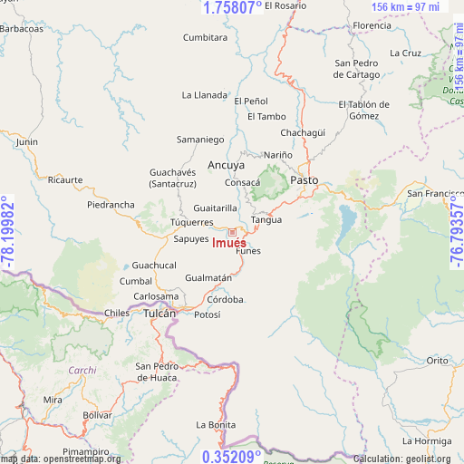
Imués GPS coordinates[2]
1° 3' 18.576" North, 77° 29' 48.084" West
| Map corner | latitude | longitude |
|---|---|---|
| Upper-left | 1.75807°, | -78.19982° |
| Center: | 1.05516°, | -77.49669° |
| Lower-right: | 0.35209°, | -76.79357° |
| Map W x H: | 156.3×156.3 km | = 97.1×97.1mi |
| max Lat: | 13.38166° ⇑97.3% North |
| Imués: | 1.05516° |
| min Lat: | ⇓2.7% South -4.21528° |
| min Long | Imués | max Long |
| -81.70636° | -77.49669° | -67.06996° |
| W 3.6%⇐ | ⇒96.4% E |
Elevation
Elevation of Imués is 2441 m = 8009 ft, and this is 1291.7 m = 4238 ft above average elevation for this country.
| Max E: |
3342 m = 10965 ft | 12.2% |
| Imués | 2441 m 8009 ft | |
| Avg. | 1149.3 m = 3771 ft | |
Min E: |
1 m = 3 ft | 87.8% |
See also: Colombia elevation on elevation.city.
Geographical zone
Imués is located in North Torrid zone (between Equator and Tropic of Cancer). Distance of Equator is 117.3 km =72.9 mi to South.| Distance of | km | miles | from Imués |
|---|---|---|---|
| North Pole | 9889.7 | 6145.2 | to North |
| Arctic Circle | 7283.9 | 4526 | to North |
| Tropic Cancer | 2488.6 | 1546.3 | to North |
| Equator | 117.3 | 72.9 | to South |


Nearby cities:
15 places around Imués: (largest is in red/bold)
• Ancuya
23.2 km =14.4 mi,  355°
355°
• Consacá
17.4 km =10.8 mi,  11°
11°
• Contadero
17.3 km =10.7 mi,  199°
199°
• Córdoba
22.5 km =14 mi,  186°
186°
• Funes
8 km =5 mi,  138°
138°
• Guaitarilla
10.2 km =6.3 mi,  325°
325°
• Gualmatán
17 km =10.6 mi,  207°
207°
• Iles
9.8 km =6.1 mi, 196°
• Olaya Herrera
21.5 km =13.4 mi,  1°
1°
• Ospina
7.7 km =4.8 mi,  273°
273°
• Puerres
19.1 km =11.9 mi,  182°
182°
• Sapuyes
14 km =8.7 mi,  261°
261°
• Tangua
12.1 km =7.5 mi,  68°
68°
• Túquerres
14 km =8.7 mi,  284°
284°
• Yacuanquer
12.5 km =7.8 mi,  57°
57°
Sources, notices
• [Note1] Compared only with cities in Colombia existing in our database
• [Src1] Map data: © OpenStreetMap contributors (CC-BY-SA)
• [Src2] Other city data from geonames.org with taken over terms of usage.
• [Src3] Geographical zone / Annual Mean Temperature by Robert A. Rohde @ Wikipedia
