Córdoba geodata
Córdoba (Nariño) is a seat of a second-order administrative division; located in Colombia in America/Bogota (GMT-5) time zone. With population of 3,784 people, there are 604 cities with bigger population in this country. Compared to other cities in Colombia, 98.9% of cities are located further ↑North; 96.7% of cities are located further →East and 95% of cities have lower elevation than Córdoba. Note1


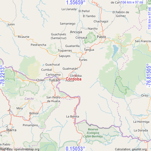
Córdoba GPS coordinates[2]
0° 51' 13.032" North, 77° 31' 5.412" West
| Map corner | latitude | longitude |
|---|---|---|
| Upper-left | 1.55659°, | -78.2213° |
| Center: | 0.85362°, | -77.51817° |
| Lower-right: | 0.15053°, | -76.81505° |
| Map W x H: | 156.3×156.3 km | = 97.1×97.1mi |
| max Lat: | 13.38166° ⇑98.9% North |
| Córdoba: | 0.85362° |
| min Lat: | ⇓1.1% South -4.21528° |
| min Long | Córdoba | max Long |
| -81.70636° | -77.51817° | -67.06996° |
| W 3.3%⇐ | ⇒96.7% E |
Elevation
Elevation of Córdoba is 2672 m = 8766 ft, and this is 1522.7 m = 4996 ft above average elevation for this country.
| Max E: |
3342 m = 10965 ft | 5% |
| Córdoba | 2672 m 8766 ft | |
| Avg. | 1149.3 m = 3771 ft | |
Min E: |
1 m = 3 ft | 95% |
See also: Colombia elevation on elevation.city.
Geographical zone
Córdoba is located in North Torrid zone (between Equator and Tropic of Cancer). Distance of Equator is 94.9 km =59 mi to South.| Distance of | km | miles | from Córdoba |
|---|---|---|---|
| North Pole | 9912.1 | 6159.1 | to North |
| Arctic Circle | 7306.3 | 4539.9 | to North |
| Tropic Cancer | 2511 | 1560.3 | to North |
| Equator | 94.9 | 59 | to South |


Nearby cities:
15 places around Córdoba: (largest is in red/bold)
• Aldana
20.6 km =12.8 mi,  279°
279°
• Carlosama
23.3 km =14.5 mi,  272°
272°
• Contadero
6.9 km =4.3 mi,  331°
331°
• Funes
18.1 km =11.2 mi,  25°
25°
• Guachucal
26.6 km =16.5 mi,  296°
296°
• Gualmatán
9.2 km =5.7 mi,  323°
323°
• Iles
13 km =8.1 mi,  358°
358°
• Imués
22.5 km =14 mi,  6°
6°
• Ipiales
13.9 km =8.6 mi,  256°
256°
• Ospina
23.5 km =14.6 mi,  347°
347°
• Potosí
7.9 km =4.9 mi,  229°
229°
• Puerres
3.7 km =2.3 mi, 26°
• Pupiales
13.7 km =8.5 mi, 278°
• Sapuyes
23.4 km =14.5 mi, 330°
• Túquerres
28.2 km =17.5 mi,  336°
336°
Sources, notices
• [Note1] Compared only with cities in Colombia existing in our database
• [Src1] Map data: © OpenStreetMap contributors (CC-BY-SA)
• [Src2] Other city data from geonames.org with taken over terms of usage.
• [Src3] Geographical zone / Annual Mean Temperature by Robert A. Rohde @ Wikipedia
