Ponedera geodata
Ponedera (Atlántico) is a seat of a second-order administrative division; located in Colombia in America/Bogota (GMT-5) time zone. With population of 11,221 people, there are 272 cities with bigger population in this country. Compared to other cities in Colombia, 97.1% of cities are located further ↓South; 52.3% of cities are located further ←West and 92.8% of cities have higher elevation than Ponedera. Note1


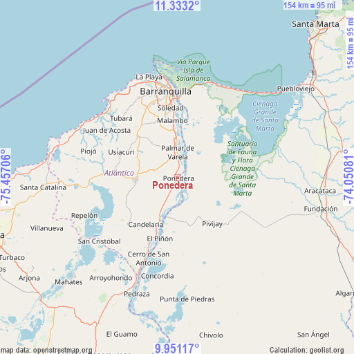
Ponedera GPS coordinates[2]
10° 38' 34.692" North, 74° 45' 14.148" West
| Map corner | latitude | longitude |
|---|---|---|
| Upper-left | 11.3332°, | -75.45706° |
| Center: | 10.64297°, | -74.75393° |
| Lower-right: | 9.95117°, | -74.05081° |
| Map W x H: | 153.7×153.7 km | = 95.5×95.5mi |
| max Lat: | 13.38166° ⇑2.9% North |
| Ponedera: | 10.64297° |
| min Lat: | ⇓97.1% South -4.21528° |
| min Long | Ponedera | max Long |
| -81.70636° | -74.75393° | -67.06996° |
| W 52.3%⇐ | ⇒47.7% E |
Elevation
Elevation of Ponedera is 20 m = 66 ft, and this is 1129.3 m = 3705 ft below average elevation for this country.
| Max E: |
3342 m = 10965 ft | 92.8% |
| Avg. | 1149.3 m = 3771 ft | |
| Ponedera | 20 m = 66 ft | |
Min E: |
1 m = 3 ft | 7.2% |
See also: Colombia elevation on elevation.city.
Geographical zone
Ponedera is located in North Torrid zone (between Equator and Tropic of Cancer). Distance of Equator is 1183.4 km =735.3 mi to South.| Distance of | km | miles | from Ponedera |
|---|---|---|---|
| North Pole | 8823.7 | 5482.8 | to North |
| Arctic Circle | 6217.8 | 3863.6 | to North |
| Tropic Cancer | 1422.5 | 883.9 | to North |
| Equator | 1183.4 | 735.3 | to South |


Nearby cities:
15 places around Ponedera: (largest is in red/bold)
• Baranoa
24.4 km =15.2 mi,  313°
313°
• Candelaria
24.6 km =15.3 mi,  213°
213°
• El Piñón
27.8 km =17.3 mi,  196°
196°
• Malambo
24.2 km =15 mi,  354°
354°
• Palmar de Varela
10.9 km =6.8 mi,  359°
359°
• Pivijay
25.2 km =15.7 mi,  143°
143°
• Polonuevo
18.4 km =11.4 mi,  323°
323°
• Remolino
7.8 km =4.8 mi,  32°
32°
• Sabanagrande
16.5 km =10.3 mi, 357°
• Sabanalarga
18.4 km =11.4 mi,  265°
265°
• Salamina
17.6 km =10.9 mi,  194°
194°
• Santo Tomás
12.8 km =8 mi, 359°
• Sitionuevo
15.4 km =9.6 mi,  13°
13°
• Soledad
30.7 km =19.1 mi, 357°
• Usiacurí
26.7 km =16.6 mi,  294°
294°
Sources, notices
• [Note1] Compared only with cities in Colombia existing in our database
• [Src1] Map data: © OpenStreetMap contributors (CC-BY-SA)
• [Src2] Other city data from geonames.org with taken over terms of usage.
• [Src3] Geographical zone / Annual Mean Temperature by Robert A. Rohde @ Wikipedia
