Polonuevo geodata
Polonuevo (Atlántico) is a seat of a second-order administrative division; located in Colombia in America/Bogota (GMT-5) time zone. With population of 11,727 people, there are 259 cities with bigger population in this country. Compared to other cities in Colombia, 97.9% of cities are located further ↓South; 50.5% of cities are located further →East and 82.8% of cities have higher elevation than Polonuevo. Note1


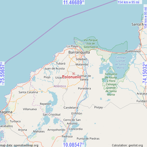
Polonuevo GPS coordinates[2]
10° 46' 37.092" North, 74° 51' 12.384" West
| Map corner | latitude | longitude |
|---|---|---|
| Upper-left | 11.46689°, | -75.55657° |
| Center: | 10.77697°, | -74.85344° |
| Lower-right: | 10.08547°, | -74.15032° |
| Map W x H: | 153.6×153.6 km | = 95.4×95.4mi |
| max Lat: | 13.38166° ⇑2.1% North |
| Polonuevo: | 10.77697° |
| min Lat: | ⇓97.9% South -4.21528° |
| min Long | Polonuevo | max Long |
| -81.70636° | -74.85344° | -67.06996° |
| W 49.5%⇐ | ⇒50.5% E |
Elevation
Elevation of Polonuevo is 86 m = 282 ft, and this is 1063.3 m = 3489 ft below average elevation for this country.
| Max E: |
3342 m = 10965 ft | 82.8% |
| Avg. | 1149.3 m = 3771 ft | |
| Polonuevo | 86 m = 282 ft | |
Min E: |
1 m = 3 ft | 17.2% |
See also: Colombia elevation on elevation.city.
Geographical zone
Polonuevo is located in North Torrid zone (between Equator and Tropic of Cancer). Distance of Equator is 1198.3 km =744.6 mi to South.| Distance of | km | miles | from Polonuevo |
|---|---|---|---|
| North Pole | 8808.8 | 5473.5 | to North |
| Arctic Circle | 6202.9 | 3854.3 | to North |
| Tropic Cancer | 1407.6 | 874.6 | to North |
| Equator | 1198.3 | 744.6 | to South |


Nearby cities:
15 places around Polonuevo: (largest is in red/bold)
• Baranoa
7.1 km =4.4 mi,  285°
285°
• Barranquilla
22.7 km =14.1 mi,  20°
20°
• Galapa
13.8 km =8.6 mi,  345°
345°
• Juan de Acosta
20.5 km =12.7 mi, 286°
• Malambo
12.6 km =7.8 mi,  43°
43°
• Palmar de Varela
11.5 km =7.1 mi,  110°
110°
• Ponedera
18.4 km =11.4 mi,  143°
143°
• Remolino
17.2 km =10.7 mi,  119°
119°
• Sabanagrande
10.3 km =6.4 mi,  81°
81°
• Sabanalarga
17.9 km =11.1 mi,  204°
204°
• Santo Tomás
11 km =6.8 mi,  101°
101°
• Sitionuevo
14.5 km =9 mi,  89°
89°
• Soledad
18.5 km =11.5 mi,  31°
31°
• Tubará
17.5 km =10.9 mi,  308°
308°
• Usiacurí
13.9 km =8.6 mi,  254°
254°
Sources, notices
• [Note1] Compared only with cities in Colombia existing in our database
• [Src1] Map data: © OpenStreetMap contributors (CC-BY-SA)
• [Src2] Other city data from geonames.org with taken over terms of usage.
• [Src3] Geographical zone / Annual Mean Temperature by Robert A. Rohde @ Wikipedia
