Santo Tomás geodata
Santo Tomás (Atlántico) is a seat of a second-order administrative division; located in Colombia in America/Bogota (GMT-5) time zone. With population of 25,847 people, there are 143 cities with bigger population in this country. Compared to other cities in Colombia, 97.6% of cities are located further ↓South; 52.1% of cities are located further ←West and 96.4% of cities have higher elevation than Santo Tomás. Note1


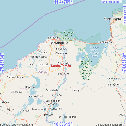
Santo Tomás GPS coordinates[2]
10° 45' 27.828" North, 74° 45' 16.236" West
| Map corner | latitude | longitude |
|---|---|---|
| Upper-left | 11.44769°, | -75.45764° |
| Center: | 10.75773°, | -74.75451° |
| Lower-right: | 10.06619°, | -74.05139° |
| Map W x H: | 153.6×153.6 km | = 95.4×95.4mi |
| max Lat: | 13.38166° ⇑2.4% North |
| Santo Tomás: | 10.75773° |
| min Lat: | ⇓97.6% South -4.21528° |
| min Long | Santo Tomás | max Long |
| -81.70636° | -74.75451° | -67.06996° |
| W 52.1%⇐ | ⇒47.9% E |
Elevation
Elevation of Santo Tomás is 10 m = 33 ft, and this is 1139.3 m = 3738 ft below average elevation for this country.
| Max E: |
3342 m = 10965 ft | 96.4% |
| Avg. | 1149.3 m = 3771 ft | |
| Santo Tomás | 10 m = 33 ft | |
Min E: |
1 m = 3 ft | 3.6% |
See also: Colombia elevation on elevation.city.
Geographical zone
Santo Tomás is located in North Torrid zone (between Equator and Tropic of Cancer). Distance of Equator is 1196.1 km =743.2 mi to South.| Distance of | km | miles | from Santo Tomás |
|---|---|---|---|
| North Pole | 8810.9 | 5474.8 | to North |
| Arctic Circle | 6205 | 3855.6 | to North |
| Tropic Cancer | 1409.8 | 876 | to North |
| Equator | 1196.1 | 743.2 | to South |


Nearby cities:
15 places around Santo Tomás: (largest is in red/bold)
• Baranoa
18.1 km =11.2 mi,  282°
282°
• Barranquilla
23.6 km =14.7 mi,  352°
352°
• Galapa
21.1 km =13.1 mi,  317°
317°
• Malambo
11.5 km =7.1 mi, 349°
• Palmar de Varela
1.9 km =1.2 mi,  179°
179°
• Polonuevo
11 km =6.8 mi, 281°
• Ponedera
12.8 km =8 mi, 179°
• Remolino
7.5 km =4.7 mi,  145°
145°
• Sabanagrande
3.8 km =2.4 mi, 349°
• Sabanalarga
23.1 km =14.4 mi,  232°
232°
• Salamina
30.1 km =18.7 mi,  188°
188°
• Sitionuevo
4.3 km =2.7 mi,  59°
59°
• Soledad
17.9 km =11.1 mi,  356°
356°
• Tubará
27.8 km =17.3 mi,  298°
298°
• Usiacurí
24.3 km =15.1 mi,  266°
266°
Sources, notices
• [Note1] Compared only with cities in Colombia existing in our database
• [Src1] Map data: © OpenStreetMap contributors (CC-BY-SA)
• [Src2] Other city data from geonames.org with taken over terms of usage.
• [Src3] Geographical zone / Annual Mean Temperature by Robert A. Rohde @ Wikipedia
