Piedrancha geodata
Piedrancha (Nariño) is a seat of a second-order administrative division; located in Colombia in America/Bogota (GMT-5) time zone. With population of 1,788 people, there are 825 cities with bigger population in this country. Compared to other cities in Colombia, 96.7% of cities are located further ↑North; 98.7% of cities are located further →East and 82.9% of cities have lower elevation than Piedrancha. Note1


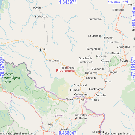
Piedrancha GPS coordinates[2]
1° 8' 27.924" North, 77° 51' 53.244" West
| Map corner | latitude | longitude |
|---|---|---|
| Upper-left | 1.84397°, | -78.56792° |
| Center: | 1.14109°, | -77.86479° |
| Lower-right: | 0.43804°, | -77.16167° |
| Map W x H: | 156.3×156.3 km | = 97.1×97.1mi |
| max Lat: | 13.38166° ⇑96.7% North |
| Piedrancha: | 1.14109° |
| min Lat: | ⇓3.3% South -4.21528° |
| min Long | Piedrancha | max Long |
| -81.70636° | -77.86479° | -67.06996° |
| W 1.3%⇐ | ⇒98.7% E |
Elevation
Elevation of Piedrancha is 2157 m = 7077 ft, and this is 1007.7 m = 3306 ft above average elevation for this country.
| Max E: |
3342 m = 10965 ft | 17.1% |
| Piedrancha | 2157 m 7077 ft | |
| Avg. | 1149.3 m = 3771 ft | |
Min E: |
1 m = 3 ft | 82.9% |
See also: Colombia elevation on elevation.city.
Geographical zone
Piedrancha is located in North Torrid zone (between Equator and Tropic of Cancer). Distance of Equator is 126.9 km =78.9 mi to South.| Distance of | km | miles | from Piedrancha |
|---|---|---|---|
| North Pole | 9880.2 | 6139.3 | to North |
| Arctic Circle | 7274.3 | 4520 | to North |
| Tropic Cancer | 2479 | 1540.4 | to North |
| Equator | 126.9 | 78.9 | to South |


Nearby cities:
15 places around Piedrancha: (largest is in red/bold)
• Aldana
34 km =21.1 mi,  147°
147°
• Ancuya
41.3 km =25.7 mi,  70°
70°
• Carlosama
34.5 km =21.4 mi, 153°
• Cumbal
27.1 km =16.8 mi,  162°
162°
• Guachavés
22.7 km =14.1 mi, 66°
• Guachucal
24.9 km =15.5 mi,  143°
143°
• Guaitarilla
35.2 km =21.9 mi,  91°
91°
• Gualmatán
41.2 km =25.6 mi,  126°
126°
• Ospina
34.5 km =21.4 mi,  105°
105°
• Providencia
31.7 km =19.7 mi, 69°
• Pupiales
39 km =24.2 mi, 140°
• Ricaurte
16.9 km =10.5 mi,  298°
298°
• Samaniego
37.1 km =23.1 mi,  53°
53°
• Sapuyes
29.5 km =18.3 mi, 113°
• Túquerres
28 km =17.4 mi,  102°
102°
Sources, notices
• [Note1] Compared only with cities in Colombia existing in our database
• [Src1] Map data: © OpenStreetMap contributors (CC-BY-SA)
• [Src2] Other city data from geonames.org with taken over terms of usage.
• [Src3] Geographical zone / Annual Mean Temperature by Robert A. Rohde @ Wikipedia
