Ricaurte geodata
Ricaurte (Nariño) is a seat of a second-order administrative division; located in Colombia in America/Bogota (GMT-5) time zone. With population of 2,617 people, there are 729 cities with bigger population in this country. Compared to other cities in Colombia, 95.9% of cities are located further ↑North; 99% of cities are located further →East and 63.5% of cities have lower elevation than Ricaurte. Note1


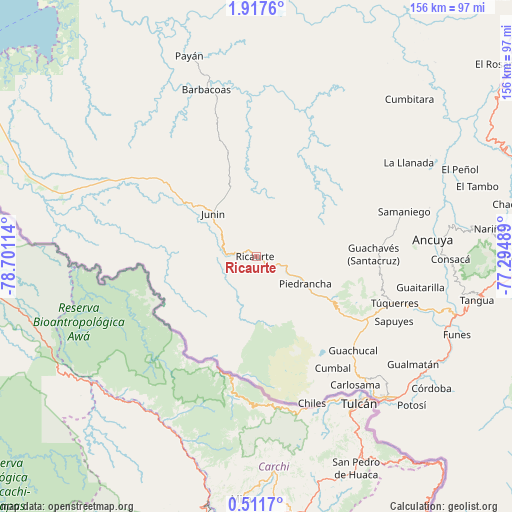
Ricaurte GPS coordinates[2]
1° 12' 53.064" North, 77° 59' 52.836" West
| Map corner | latitude | longitude |
|---|---|---|
| Upper-left | 1.9176°, | -78.70114° |
| Center: | 1.21474°, | -77.99801° |
| Lower-right: | 0.5117°, | -77.29489° |
| Map W x H: | 156.3×156.3 km | = 97.1×97.1mi |
| max Lat: | 13.38166° ⇑95.9% North |
| Ricaurte: | 1.21474° |
| min Lat: | ⇓4.1% South -4.21528° |
| min Long | Ricaurte | max Long |
| -81.70636° | -77.99801° | -67.06996° |
| W 1%⇐ | ⇒99% E |
Elevation
Elevation of Ricaurte is 1560 m = 5118 ft, and this is 410.7 m = 1347 ft above average elevation for this country.
| Max E: |
3342 m = 10965 ft | 36.5% |
| Ricaurte | 1560 m 5118 ft | |
| Avg. | 1149.3 m = 3771 ft | |
Min E: |
1 m = 3 ft | 63.5% |
See also: Colombia elevation on elevation.city.
Geographical zone
Ricaurte is located in North Torrid zone (between Equator and Tropic of Cancer). Distance of Equator is 135.1 km =83.9 mi to South.| Distance of | km | miles | from Ricaurte |
|---|---|---|---|
| North Pole | 9872 | 6134.2 | to North |
| Arctic Circle | 7266.1 | 4514.9 | to North |
| Tropic Cancer | 2470.9 | 1535.3 | to North |
| Equator | 135.1 | 83.9 | to South |


Nearby cities:
15 places around Ricaurte: (largest is in red/bold)
• Aldana
49.5 km =30.8 mi,  138°
138°
• Ancuya
54.1 km =33.6 mi,  84°
84°
• Barbacoas
53.2 km =33.1 mi,  342°
342°
• Carlosama
49.4 km =30.7 mi, 142°
• Cumbal
41 km =25.5 mi,  145°
145°
• Guachavés
35.6 km =22.1 mi,  88°
88°
• Guachucal
40.9 km =25.4 mi,  133°
133°
• Guaitarilla
50.9 km =31.6 mi,  100°
100°
• La Llanada
54.6 km =33.9 mi,  58°
58°
• Ospina
51.1 km =31.8 mi,  109°
109°
• Piedrancha
16.9 km =10.5 mi,  118°
118°
• Providencia
44.6 km =27.7 mi, 86°
• Samaniego
46.8 km =29.1 mi,  72°
72°
• Sapuyes
46.3 km =28.8 mi, 115°
• Túquerres
44.5 km =27.7 mi, 108°
Sources, notices
• [Note1] Compared only with cities in Colombia existing in our database
• [Src1] Map data: © OpenStreetMap contributors (CC-BY-SA)
• [Src2] Other city data from geonames.org with taken over terms of usage.
• [Src3] Geographical zone / Annual Mean Temperature by Robert A. Rohde @ Wikipedia
