Ovejas geodata
Ovejas (Sucre) is a seat of a second-order administrative division; located in Colombia in America/Bogota (GMT-5) time zone. With population of 13,284 people, there are 241 cities with bigger population in this country. Compared to other cities in Colombia, 91.2% of cities are located further ↓South; 59.7% of cities are located further →East and 71.9% of cities have higher elevation than Ovejas. Note1


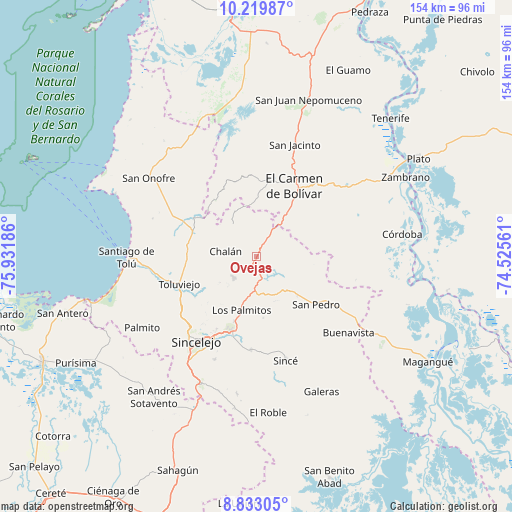
Ovejas GPS coordinates[2]
9° 31' 37.776" North, 75° 13' 43.428" West
| Map corner | latitude | longitude |
|---|---|---|
| Upper-left | 10.21987°, | -75.93186° |
| Center: | 9.52716°, | -75.22873° |
| Lower-right: | 8.83305°, | -74.52561° |
| Map W x H: | 154.2×154.2 km | = 95.8×95.8mi |
| max Lat: | 13.38166° ⇑8.8% North |
| Ovejas: | 9.52716° |
| min Lat: | ⇓91.2% South -4.21528° |
| min Long | Ovejas | max Long |
| -81.70636° | -75.22873° | -67.06996° |
| W 40.3%⇐ | ⇒59.7% E |
Elevation
Elevation of Ovejas is 255 m = 837 ft, and this is 894.3 m = 2934 ft below average elevation for this country.
| Max E: |
3342 m = 10965 ft | 71.9% |
| Avg. | 1149.3 m = 3771 ft | |
| Ovejas | 255 m = 837 ft | |
Min E: |
1 m = 3 ft | 28.1% |
See also: Colombia elevation on elevation.city.
Geographical zone
Ovejas is located in North Torrid zone (between Equator and Tropic of Cancer). Distance of Equator is 1059.3 km =658.2 mi to South.| Distance of | km | miles | from Ovejas |
|---|---|---|---|
| North Pole | 8947.7 | 5559.8 | to North |
| Arctic Circle | 6341.9 | 3940.7 | to North |
| Tropic Cancer | 1546.6 | 961 | to North |
| Equator | 1059.3 | 658.2 | to South |


Nearby cities:
15 places around Ovejas: (largest is in red/bold)
• Buenavista
36.3 km =22.6 mi,  129°
129°
• Chalán
9.3 km =5.8 mi,  284°
284°
• Colosó
14.1 km =8.8 mi,  255°
255°
• Corozal
24.3 km =15.1 mi,  196°
196°
• El Carmen de Bolívar
24.3 km =15.1 mi,  29°
29°
• Los Palmitos
17 km =10.6 mi,  194°
194°
• Morroa
23.1 km =14.4 mi, 201°
• San Cristóbal
39.1 km =24.3 mi,  356°
356°
• San Jacinto
35.4 km =22 mi,  19°
19°
• San Juan de Betulia
28.2 km =17.5 mi,  182°
182°
• San Luis de Sincé
32.8 km =20.4 mi,  164°
164°
• San Pedro
23.2 km =14.4 mi, 129°
• Santiago de Tolú
38.7 km =24 mi,  269°
269°
• Sincelejo
30.9 km =19.2 mi,  216°
216°
• Tolú Viejo
24.5 km =15.2 mi,  249°
249°
Sources, notices
• [Note1] Compared only with cities in Colombia existing in our database
• [Src1] Map data: © OpenStreetMap contributors (CC-BY-SA)
• [Src2] Other city data from geonames.org with taken over terms of usage.
• [Src3] Geographical zone / Annual Mean Temperature by Robert A. Rohde @ Wikipedia
