Chalán geodata
Chalán (Sucre) is a seat of a second-order administrative division; located in Colombia in America/Bogota (GMT-5) time zone. With population of 2,897 people, there are 692 cities with bigger population in this country. Compared to other cities in Colombia, 91.3% of cities are located further ↓South; 61.9% of cities are located further →East and 70.2% of cities have higher elevation than Chalán. Note1


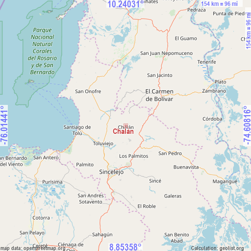
Chalán GPS coordinates[2]
9° 32' 51.54" North, 75° 18' 40.608" West
| Map corner | latitude | longitude |
|---|---|---|
| Upper-left | 10.24031°, | -76.01441° |
| Center: | 9.54765°, | -75.31128° |
| Lower-right: | 8.85358°, | -74.60816° |
| Map W x H: | 154.2×154.2 km | = 95.8×95.8mi |
| max Lat: | 13.38166° ⇑8.7% North |
| Chalán: | 9.54765° |
| min Lat: | ⇓91.3% South -4.21528° |
| min Long | Chalán | max Long |
| -81.70636° | -75.31128° | -67.06996° |
| W 38.1%⇐ | ⇒61.9% E |
Elevation
Elevation of Chalán is 289 m = 948 ft, and this is 860.3 m = 2823 ft below average elevation for this country.
| Max E: |
3342 m = 10965 ft | 70.2% |
| Avg. | 1149.3 m = 3771 ft | |
| Chalán | 289 m = 948 ft | |
Min E: |
1 m = 3 ft | 29.8% |
See also: Colombia elevation on elevation.city.
Geographical zone
Chalán is located in North Torrid zone (between Equator and Tropic of Cancer). Distance of Equator is 1061.6 km =659.6 mi to South.| Distance of | km | miles | from Chalán |
|---|---|---|---|
| North Pole | 8945.5 | 5558.5 | to North |
| Arctic Circle | 6339.6 | 3939.2 | to North |
| Tropic Cancer | 1544.3 | 959.6 | to North |
| Equator | 1061.6 | 659.6 | to South |


Nearby cities:
15 places around Chalán: (largest is in red/bold)
• Colosó
7.4 km =4.6 mi,  217°
217°
• Corozal
25.6 km =15.9 mi,  175°
175°
• El Carmen de Bolívar
28.2 km =17.5 mi,  47°
47°
• Los Palmitos
19.4 km =12.1 mi,  165°
165°
• Morroa
23.8 km =14.8 mi, 178°
• Ovejas
9.3 km =5.8 mi,  104°
104°
• Palmito
34.8 km =21.6 mi,  226°
226°
• San Cristóbal
37.3 km =23.2 mi,  9°
9°
• San Jacinto
37.4 km =23.2 mi,  33°
33°
• San Juan de Betulia
31.4 km =19.5 mi, 165°
• San Onofre
31.5 km =19.6 mi,  311°
311°
• San Pedro
31.9 km =19.8 mi,  122°
122°
• Santiago de Tolú
29.7 km =18.5 mi,  264°
264°
• Sincelejo
28.6 km =17.8 mi,  199°
199°
• Tolú Viejo
17.6 km =10.9 mi, 232°
Sources, notices
• [Note1] Compared only with cities in Colombia existing in our database
• [Src1] Map data: © OpenStreetMap contributors (CC-BY-SA)
• [Src2] Other city data from geonames.org with taken over terms of usage.
• [Src3] Geographical zone / Annual Mean Temperature by Robert A. Rohde @ Wikipedia
