Magangué geodata
Magangué (Bolívar) is a seat of a second-order administrative division; located in Colombia in America/Bogota (GMT-5) time zone. With population of 100,313 people, there are 39 cities with bigger population in this country. Compared to other cities in Colombia, 88.8% of cities are located further ↓South; 52% of cities are located further ←West and 92.8% of cities have higher elevation than Magangué. Note1


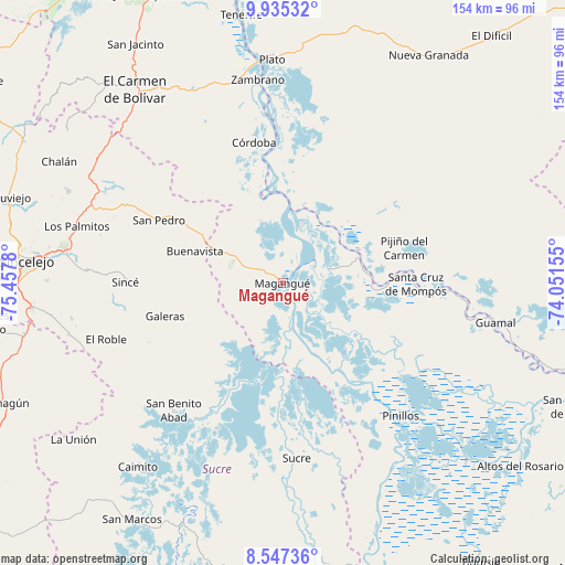
Magangué GPS coordinates[2]
9° 14' 31.272" North, 74° 45' 16.812" West
| Map corner | latitude | longitude |
|---|---|---|
| Upper-left | 9.93532°, | -75.4578° |
| Center: | 9.24202°, | -74.75467° |
| Lower-right: | 8.54736°, | -74.05155° |
| Map W x H: | 154.3×154.3 km | = 95.9×95.9mi |
| max Lat: | 13.38166° ⇑11.2% North |
| Magangué: | 9.24202° |
| min Lat: | ⇓88.8% South -4.21528° |
| min Long | Magangué | max Long |
| -81.70636° | -74.75467° | -67.06996° |
| W 52%⇐ | ⇒48% E |
Elevation
Elevation of Magangué is 20 m = 66 ft, and this is 1129.3 m = 3705 ft below average elevation for this country.
| Max E: |
3342 m = 10965 ft | 92.8% |
| Avg. | 1149.3 m = 3771 ft | |
| Magangué | 20 m = 66 ft | |
Min E: |
1 m = 3 ft | 7.2% |
See also: Magangué elevation on elevation.city.
Geographical zone
Magangué is located in North Torrid zone (between Equator and Tropic of Cancer). Distance of Equator is 1027.6 km =638.5 mi to South.| Distance of | km | miles | from Magangué |
|---|---|---|---|
| North Pole | 8979.4 | 5579.5 | to North |
| Arctic Circle | 6373.6 | 3960.4 | to North |
| Tropic Cancer | 1578.3 | 980.7 | to North |
| Equator | 1027.6 | 638.5 | to South |


Nearby cities:
15 places around Magangué: (largest is in red/bold)
• Buenavista
25.5 km =15.8 mi,  289°
289°
• Cicuco
12.9 km =8 mi,  72°
72°
• Córdoba
39.1 km =24.3 mi,  348°
348°
• Galeras
33.4 km =20.8 mi,  254°
254°
• Mompós
36 km =22.4 mi,  90°
90°
• Pijiño del Carmen
34.5 km =21.4 mi, 73°
• San Fernando
24.6 km =15.3 mi,  80°
80°
• San Luis de Sincé
43 km =26.7 mi,  270°
270°
• San Pedro
38.1 km =23.7 mi,  296°
296°
• San Sebastián de Buenavista
44.2 km =27.5 mi, 90°
• San Zenón
27.9 km =17.3 mi, 89°
• Santa Ana
22.2 km =13.8 mi, 66°
• Santa Bárbara de Pinto
21.9 km =13.6 mi,  14°
14°
• Talaigua Nuevo
21.9 km =13.6 mi, 71°
• Talaigua Viejo
20.1 km =12.5 mi, 67°
Sources, notices
• [Note1] Compared only with cities in Colombia existing in our database
• [Src1] Map data: © OpenStreetMap contributors (CC-BY-SA)
• [Src2] Other city data from geonames.org with taken over terms of usage.
• [Src3] Geographical zone / Annual Mean Temperature by Robert A. Rohde @ Wikipedia
