Macanal geodata
Macanal (Boyacá) is a seat of a second-order administrative division; located in Colombia in America/Bogota (GMT-5) time zone. With population of 734 people, there are 994 cities with bigger population in this country. Compared to other cities in Colombia, 62.8% of cities are located further ↑North; 80% of cities are located further ←West and 68% of cities have lower elevation than Macanal. Note1


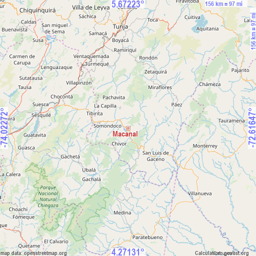
Macanal GPS coordinates[2]
4° 58' 19.704" North, 73° 19' 10.524" West
| Map corner | latitude | longitude |
|---|---|---|
| Upper-left | 5.67223°, | -74.02272° |
| Center: | 4.97214°, | -73.31959° |
| Lower-right: | 4.27131°, | -72.61647° |
| Map W x H: | 155.8×155.8 km | = 96.8×96.8mi |
| max Lat: | 13.38166° ⇑62.8% North |
| Macanal: | 4.97214° |
| min Lat: | ⇓37.2% South -4.21528° |
| min Long | Macanal | max Long |
| -81.70636° | -73.31959° | -67.06996° |
| W 80%⇐ | ⇒20% E |
Elevation
Elevation of Macanal is 1674 m = 5492 ft, and this is 524.7 m = 1721 ft above average elevation for this country.
| Max E: |
3342 m = 10965 ft | 32% |
| Macanal | 1674 m 5492 ft | |
| Avg. | 1149.3 m = 3771 ft | |
Min E: |
1 m = 3 ft | 68% |
See also: Colombia elevation on elevation.city.
Geographical zone
Macanal is located in North Torrid zone (between Equator and Tropic of Cancer). Distance of Equator is 552.9 km =343.6 mi to South.| Distance of | km | miles | from Macanal |
|---|---|---|---|
| North Pole | 9454.2 | 5874.6 | to North |
| Arctic Circle | 6848.3 | 4255.3 | to North |
| Tropic Cancer | 2053.1 | 1275.7 | to North |
| Equator | 552.9 | 343.6 | to South |


Nearby cities:
15 places around Macanal: (largest is in red/bold)
• Almeida
6.7 km =4.2 mi,  268°
268°
• Campohermoso
24.8 km =15.4 mi,  74°
74°
• Chinavita
22.4 km =13.9 mi,  346°
346°
• Chivor
11.1 km =6.9 mi,  209°
209°
• Garagoa
13.2 km =8.2 mi,  338°
338°
• Guateque
17.4 km =10.8 mi,  282°
282°
• Guayatá
18.6 km =11.6 mi, 267°
• La Capilla
19.5 km =12.1 mi,  314°
314°
• Pachavita
20.5 km =12.7 mi, 335°
• San Luis de Gaceno
23.8 km =14.8 mi,  135°
135°
• Santa María
13.9 km =8.6 mi,  152°
152°
• Somondoco
12.6 km =7.8 mi, 276°
• Sutatenza
15.8 km =9.8 mi,  291°
291°
• Tenza
16.1 km =10 mi,  316°
316°
• Tibirita
22.3 km =13.9 mi, 293°
Sources, notices
• [Note1] Compared only with cities in Colombia existing in our database
• [Src1] Map data: © OpenStreetMap contributors (CC-BY-SA)
• [Src2] Other city data from geonames.org with taken over terms of usage.
• [Src3] Geographical zone / Annual Mean Temperature by Robert A. Rohde @ Wikipedia
