Chivor geodata
Chivor (Boyacá) is a seat of a second-order administrative division; located in Colombia in America/Bogota (GMT-5) time zone. With population of 1,622 people, there are 849 cities with bigger population in this country. Compared to other cities in Colombia, 64.5% of cities are located further ↑North; 78.4% of cities are located further ←West and 75.8% of cities have lower elevation than Chivor. Note1


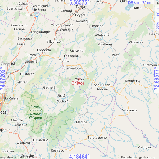
Chivor GPS coordinates[2]
4° 53' 8.016" North, 73° 22' 8.004" West
| Map corner | latitude | longitude |
|---|---|---|
| Upper-left | 5.58575°, | -74.07202° |
| Center: | 4.88556°, | -73.36889° |
| Lower-right: | 4.18464°, | -72.66577° |
| Map W x H: | 155.8×155.8 km | = 96.8×96.8mi |
| max Lat: | 13.38166° ⇑64.5% North |
| Chivor: | 4.88556° |
| min Lat: | ⇓35.5% South -4.21528° |
| min Long | Chivor | max Long |
| -81.70636° | -73.36889° | -67.06996° |
| W 78.4%⇐ | ⇒21.6% E |
Elevation
Elevation of Chivor is 1885 m = 6184 ft, and this is 735.7 m = 2414 ft above average elevation for this country.
| Max E: |
3342 m = 10965 ft | 24.2% |
| Chivor | 1885 m 6184 ft | |
| Avg. | 1149.3 m = 3771 ft | |
Min E: |
1 m = 3 ft | 75.8% |
See also: Colombia elevation on elevation.city.
Geographical zone
Chivor is located in North Torrid zone (between Equator and Tropic of Cancer). Distance of Equator is 543.2 km =337.5 mi to South.| Distance of | km | miles | from Chivor |
|---|---|---|---|
| North Pole | 9463.8 | 5880.5 | to North |
| Arctic Circle | 6858 | 4261.4 | to North |
| Tropic Cancer | 2062.7 | 1281.7 | to North |
| Equator | 543.2 | 337.5 | to South |


Nearby cities:
15 places around Chivor: (largest is in red/bold)
• Almeida
9.6 km =6 mi,  352°
352°
• Gachalá
27.3 km =17 mi,  218°
218°
• Garagoa
21.9 km =13.6 mi,  1°
1°
• Guateque
17.7 km =11 mi,  319°
319°
• Guayatá
15.8 km =9.8 mi,  303°
303°
• La Capilla
24.8 km =15.4 mi,  340°
340°
• Macanal
11.1 km =6.9 mi,  29°
29°
• Manta
23.5 km =14.6 mi,  305°
305°
• San Luis de Gaceno
23.3 km =14.5 mi,  108°
108°
• Santa María
12.1 km =7.5 mi,  103°
103°
• Somondoco
13.1 km =8.1 mi,  327°
327°
• Sutatenza
17.9 km =11.1 mi, 328°
• Tenza
22 km =13.7 mi, 344°
• Tibirita
23.9 km =14.9 mi, 320°
• Ubalá
24.2 km =15 mi,  229°
229°
Sources, notices
• [Note1] Compared only with cities in Colombia existing in our database
• [Src1] Map data: © OpenStreetMap contributors (CC-BY-SA)
• [Src2] Other city data from geonames.org with taken over terms of usage.
• [Src3] Geographical zone / Annual Mean Temperature by Robert A. Rohde @ Wikipedia
