San Luis de Gaceno geodata
San Luis de Gaceno (Boyacá) is a seat of a second-order administrative division; located in Colombia in America/Bogota (GMT-5) time zone. With population of 2,579 people, there are 733 cities with bigger population in this country. Compared to other cities in Colombia, 66% of cities are located further ↑North; 83.7% of cities are located further ←West and 66.4% of cities have higher elevation than San Luis de Gaceno. Note1


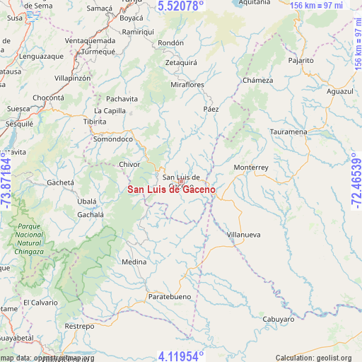
San Luis de Gaceno GPS coordinates[2]
4° 49' 13.872" North, 73° 10' 6.636" West
| Map corner | latitude | longitude |
|---|---|---|
| Upper-left | 5.52078°, | -73.87164° |
| Center: | 4.82052°, | -73.16851° |
| Lower-right: | 4.11954°, | -72.46539° |
| Map W x H: | 155.8×155.8 km | = 96.8×96.8mi |
| max Lat: | 13.38166° ⇑66% North |
| San Luis de Gaceno: | 4.82052° |
| min Lat: | ⇓34% South -4.21528° |
| min Long | San Luis de Gac | max Long |
| -81.70636° | -73.16851° | -67.06996° |
| W 83.7%⇐ | ⇒16.3% E |
Elevation
Elevation of San Luis de Gaceno is 395 m = 1296 ft, and this is 754.3 m = 2475 ft below average elevation for this country.
| Max E: |
3342 m = 10965 ft | 66.4% |
| Avg. | 1149.3 m = 3771 ft | |
| San Luis de Gaceno | 395 m = 1296 ft | |
Min E: |
1 m = 3 ft | 33.6% |
See also: Colombia elevation on elevation.city.
Geographical zone
San Luis de Gaceno is located in North Torrid zone (between Equator and Tropic of Cancer). Distance of Equator is 536 km =333.1 mi to South.| Distance of | km | miles | from San Luis de Gaceno |
|---|---|---|---|
| North Pole | 9471.1 | 5885.1 | to North |
| Arctic Circle | 6865.2 | 4265.8 | to North |
| Tropic Cancer | 2069.9 | 1286.2 | to North |
| Equator | 536 | 333.1 | to South |


Nearby cities:
15 places around San Luis de Gaceno: (largest is in red/bold)
• Almeida
28.8 km =17.9 mi,  305°
305°
• Barranca de Upía
35.7 km =22.2 mi,  141°
141°
• Campohermoso
24.5 km =15.2 mi,  17°
17°
• Chivor
23.3 km =14.5 mi,  288°
288°
• Garagoa
36.2 km =22.5 mi,  323°
323°
• Guateque
39.5 km =24.5 mi,  301°
301°
• Guayatá
38.8 km =24.1 mi, 294°
• Macanal
23.8 km =14.8 mi, 315°
• Monterrey
30.9 km =19.2 mi,  78°
78°
• Páez
33.8 km =21 mi, 22°
• Sabanalarga
14.7 km =9.1 mi, 75°
• Santa María
11.3 km =7 mi, 293°
• Somondoco
34.5 km =21.4 mi, 302°
• Sutatenza
38.7 km =24 mi, 305°
• Villanueva
35.4 km =22 mi,  130°
130°
Sources, notices
• [Note1] Compared only with cities in Colombia existing in our database
• [Src1] Map data: © OpenStreetMap contributors (CC-BY-SA)
• [Src2] Other city data from geonames.org with taken over terms of usage.
• [Src3] Geographical zone / Annual Mean Temperature by Robert A. Rohde @ Wikipedia
