Campohermoso geodata
Campohermoso (Boyacá) is a seat of a second-order administrative division; located in Colombia in America/Bogota (GMT-5) time zone. With population of 695 people, there are 1003 cities with bigger population in this country. Compared to other cities in Colombia, 61.2% of cities are located further ↑North; 84.7% of cities are located further ←West and 50.4% of cities have higher elevation than Campohermoso. Note1


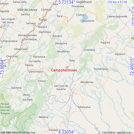
Campohermoso GPS coordinates[2]
5° 1' 52.752" North, 73° 6' 11.772" West
| Map corner | latitude | longitude |
|---|---|---|
| Upper-left | 5.73134°, | -73.8064° |
| Center: | 5.03132°, | -73.10327° |
| Lower-right: | 4.33054°, | -72.40015° |
| Map W x H: | 155.8×155.8 km | = 96.8×96.8mi |
| max Lat: | 13.38166° ⇑61.2% North |
| Campohermoso: | 5.03132° |
| min Lat: | ⇓38.8% South -4.21528° |
| min Long | Campohermoso | max Long |
| -81.70636° | -73.10327° | -67.06996° |
| W 84.7%⇐ | ⇒15.3% E |
Elevation
Elevation of Campohermoso is 1111 m = 3645 ft, and this is 38.3 m = 126 ft below average elevation for this country.
| Max E: |
3342 m = 10965 ft | 50.4% |
| Avg. | 1149.3 m = 3771 ft | |
| Campohermoso | 1111 m = 3645 ft | |
Min E: |
1 m = 3 ft | 49.6% |
See also: Colombia elevation on elevation.city.
Geographical zone
Campohermoso is located in North Torrid zone (between Equator and Tropic of Cancer). Distance of Equator is 559.4 km =347.6 mi to South.| Distance of | km | miles | from Campohermoso |
|---|---|---|---|
| North Pole | 9447.6 | 5870.5 | to North |
| Arctic Circle | 6841.7 | 4251.2 | to North |
| Tropic Cancer | 2046.5 | 1271.6 | to North |
| Equator | 559.4 | 347.6 | to South |


Nearby cities:
15 places around Campohermoso: (largest is in red/bold)
• Almeida
31.4 km =19.5 mi,  257°
257°
• Berbeo
21.9 km =13.6 mi,  353°
353°
• Chinavita
33 km =20.5 mi,  297°
297°
• Chivor
33.6 km =20.9 mi,  241°
241°
• Chámeza
32.9 km =20.4 mi,  51°
51°
• Garagoa
29.4 km =18.3 mi,  281°
281°
• Macanal
24.8 km =15.4 mi,  254°
254°
• Miraflores
18.9 km =11.7 mi, 345°
• Monterrey
28.6 km =17.8 mi,  126°
126°
• Páez
9.7 km =6 mi,  36°
36°
• Sabanalarga
20.9 km =13 mi,  160°
160°
• San Eduardo
21.6 km =13.4 mi,  7°
7°
• San Luis de Gaceno
24.5 km =15.2 mi,  197°
197°
• Santa María
25.9 km =16.1 mi,  222°
222°
• Zetaquira
28.8 km =17.9 mi, 345°
Sources, notices
• [Note1] Compared only with cities in Colombia existing in our database
• [Src1] Map data: © OpenStreetMap contributors (CC-BY-SA)
• [Src2] Other city data from geonames.org with taken over terms of usage.
• [Src3] Geographical zone / Annual Mean Temperature by Robert A. Rohde @ Wikipedia
