La Pintada geodata
La Pintada (Antioquia) is a seat of a second-order administrative division; located in Colombia in America/Bogota (GMT-5) time zone. With population of 5,342 people, there are 486 cities with bigger population in this country. Compared to other cities in Colombia, 54.8% of cities are located further ↓South; 69.3% of cities are located further →East and 62.3% of cities have higher elevation than La Pintada. Note1


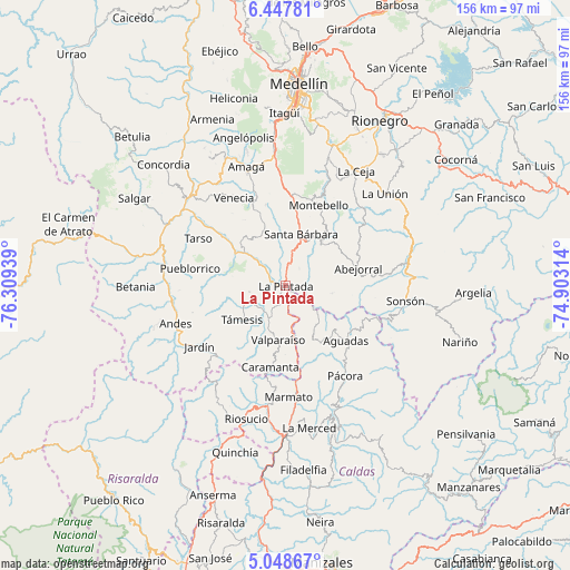
La Pintada GPS coordinates[2]
5° 44' 55.212" North, 75° 36' 22.536" West
| Map corner | latitude | longitude |
|---|---|---|
| Upper-left | 6.44781°, | -76.30939° |
| Center: | 5.74867°, | -75.60626° |
| Lower-right: | 5.04867°, | -74.90314° |
| Map W x H: | 155.6×155.6 km | = 96.7×96.7mi |
| max Lat: | 13.38166° ⇑45.2% North |
| La Pintada: | 5.74867° |
| min Lat: | ⇓54.8% South -4.21528° |
| min Long | La Pintada | max Long |
| -81.70636° | -75.60626° | -67.06996° |
| W 30.7%⇐ | ⇒69.3% E |
Elevation
Elevation of La Pintada is 602 m = 1975 ft, and this is 547.3 m = 1796 ft below average elevation for this country.
| Max E: |
3342 m = 10965 ft | 62.3% |
| Avg. | 1149.3 m = 3771 ft | |
| La Pintada | 602 m = 1975 ft | |
Min E: |
1 m = 3 ft | 37.7% |
See also: Colombia elevation on elevation.city.
Geographical zone
La Pintada is located in North Torrid zone (between Equator and Tropic of Cancer). Distance of Equator is 639.2 km =397.2 mi to South.| Distance of | km | miles | from La Pintada |
|---|---|---|---|
| North Pole | 9367.9 | 5820.9 | to North |
| Arctic Circle | 6762 | 4201.7 | to North |
| Tropic Cancer | 1966.7 | 1222.1 | to North |
| Equator | 639.2 | 397.2 | to South |


Nearby cities:
15 places around La Pintada: (largest is in red/bold)
• Abejorral
20.3 km =12.6 mi,  77°
77°
• Aguadas
22.5 km =14 mi,  132°
132°
• Caramanta
22.7 km =14.1 mi,  190°
190°
• Fredonia
20.9 km =13 mi,  340°
340°
• Jardín
28.9 km =18 mi,  234°
234°
• Jericó
20.5 km =12.7 mi,  283°
283°
• Marmato
30.4 km =18.9 mi,  178°
178°
• Montebello
23.8 km =14.8 mi,  21°
21°
• Pueblorrico
26.4 km =16.4 mi, 280°
• Pácora
29.5 km =18.3 mi,  146°
146°
• Santa Bárbara
14.7 km =9.1 mi, 17°
• Tarso
27.1 km =16.8 mi,  298°
298°
• Támesis
15.1 km =9.4 mi, 231°
• Valparaíso
15 km =9.3 mi, 187°
• Venecia
27.9 km =17.3 mi,  328°
328°
Sources, notices
• [Note1] Compared only with cities in Colombia existing in our database
• [Src1] Map data: © OpenStreetMap contributors (CC-BY-SA)
• [Src2] Other city data from geonames.org with taken over terms of usage.
• [Src3] Geographical zone / Annual Mean Temperature by Robert A. Rohde @ Wikipedia
