Santa Bárbara geodata
Santa Bárbara (Antioquia) is a seat of a second-order administrative division; located in Colombia in America/Bogota (GMT-5) time zone. With population of 12,743 people, there are 248 cities with bigger population in this country. Compared to other cities in Colombia, 57.1% of cities are located further ↓South; 68.2% of cities are located further →East and 72.9% of cities have lower elevation than Santa Bárbara. Note1


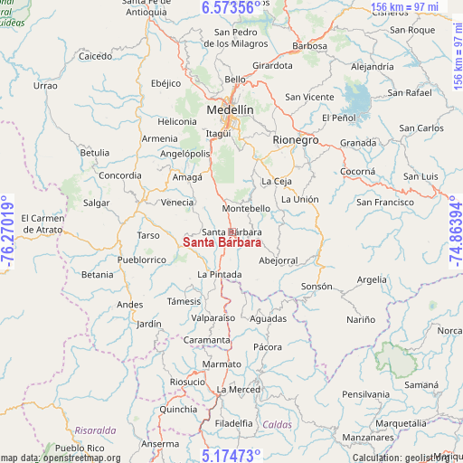
Santa Bárbara GPS coordinates[2]
5° 52' 28.488" North, 75° 34' 1.416" West
| Map corner | latitude | longitude |
|---|---|---|
| Upper-left | 6.57356°, | -76.27019° |
| Center: | 5.87458°, | -75.56706° |
| Lower-right: | 5.17473°, | -74.86394° |
| Map W x H: | 155.5×155.5 km | = 96.6×96.6mi |
| max Lat: | 13.38166° ⇑42.9% North |
| Santa Bárbara: | 5.87458° |
| min Lat: | ⇓57.1% South -4.21528° |
| min Long | Santa Bárbara | max Long |
| -81.70636° | -75.56706° | -67.06996° |
| W 31.8%⇐ | ⇒68.2% E |
Elevation
Elevation of Santa Bárbara is 1792 m = 5879 ft, and this is 642.7 m = 2109 ft above average elevation for this country.
| Max E: |
3342 m = 10965 ft | 27.1% |
| Santa Bárbara | 1792 m 5879 ft | |
| Avg. | 1149.3 m = 3771 ft | |
Min E: |
1 m = 3 ft | 72.9% |
See also: Colombia elevation on elevation.city.
Geographical zone
Santa Bárbara is located in North Torrid zone (between Equator and Tropic of Cancer). Distance of Equator is 653.2 km =405.9 mi to South.| Distance of | km | miles | from Santa Bárbara |
|---|---|---|---|
| North Pole | 9353.9 | 5812.2 | to North |
| Arctic Circle | 6748 | 4193 | to North |
| Tropic Cancer | 1952.7 | 1213.4 | to North |
| Equator | 653.2 | 405.9 | to South |


Nearby cities:
15 places around Santa Bárbara: (largest is in red/bold)
• Abejorral
18.1 km =11.2 mi,  121°
121°
• Amagá
23.8 km =14.8 mi,  320°
320°
• Angelópolis
30.6 km =19 mi,  329°
329°
• Caldas
25.2 km =15.7 mi,  342°
342°
• Fredonia
12.8 km =8 mi,  296°
296°
• Jericó
25.9 km =16.1 mi,  249°
249°
• La Ceja
22.9 km =14.2 mi,  40°
40°
• La Pintada
14.7 km =9.1 mi,  197°
197°
• La Unión
25.2 km =15.7 mi,  63°
63°
• Montebello
9.3 km =5.8 mi,  28°
28°
• Retiro
21.7 km =13.5 mi,  19°
19°
• Tarso
28.2 km =17.5 mi,  267°
267°
• Támesis
28.4 km =17.6 mi,  214°
214°
• Valparaíso
29.5 km =18.3 mi,  192°
192°
• Venecia
21.3 km =13.2 mi, 297°
Sources, notices
• [Note1] Compared only with cities in Colombia existing in our database
• [Src1] Map data: © OpenStreetMap contributors (CC-BY-SA)
• [Src2] Other city data from geonames.org with taken over terms of usage.
• [Src3] Geographical zone / Annual Mean Temperature by Robert A. Rohde @ Wikipedia
