La Llanada geodata
La Llanada (Nariño) is a seat of a second-order administrative division; located in Colombia in America/Bogota (GMT-5) time zone. With population of 2,747 people, there are 706 cities with bigger population in this country. Compared to other cities in Colombia, 94% of cities are located further ↑North; 97.5% of cities are located further →East and 78.2% of cities have lower elevation than La Llanada. Note1


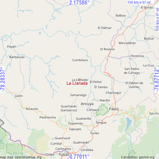
La Llanada GPS coordinates[2]
1° 28' 23.16" North, 77° 34' 48.864" West
| Map corner | latitude | longitude |
|---|---|---|
| Upper-left | 2.17586°, | -78.28337° |
| Center: | 1.4731°, | -77.58024° |
| Lower-right: | 0.77011°, | -76.87712° |
| Map W x H: | 156.3×156.3 km | = 97.1×97.1mi |
| max Lat: | 13.38166° ⇑94% North |
| La Llanada: | 1.4731° |
| min Lat: | ⇓6% South -4.21528° |
| min Long | La Llanada | max Long |
| -81.70636° | -77.58024° | -67.06996° |
| W 2.5%⇐ | ⇒97.5% E |
Elevation
Elevation of La Llanada is 1978 m = 6490 ft, and this is 828.7 m = 2719 ft above average elevation for this country.
| Max E: |
3342 m = 10965 ft | 21.8% |
| La Llanada | 1978 m 6490 ft | |
| Avg. | 1149.3 m = 3771 ft | |
Min E: |
1 m = 3 ft | 78.2% |
See also: Colombia elevation on elevation.city.
Geographical zone
La Llanada is located in North Torrid zone (between Equator and Tropic of Cancer). Distance of Equator is 163.8 km =101.8 mi to South.| Distance of | km | miles | from La Llanada |
|---|---|---|---|
| North Pole | 9843.3 | 6116.3 | to North |
| Arctic Circle | 7237.4 | 4497.1 | to North |
| Tropic Cancer | 2442.1 | 1517.5 | to North |
| Equator | 163.8 | 101.8 | to South |


Nearby cities:
15 places around La Llanada: (largest is in red/bold)
• Ancuya
24.5 km =15.2 mi,  162°
162°
• Cumbitara
19.4 km =12.1 mi,  0°
0°
• El Peñol
15.7 km =9.8 mi,  97°
97°
• El Tambo
22.1 km =13.7 mi,  109°
109°
• Guachavés
29.9 km =18.6 mi,  201°
201°
• La Florida
27.4 km =17 mi,  135°
135°
• Linares
15 km =9.3 mi, 155°
• Nariño
32.1 km =19.9 mi,  129°
129°
• Olaya Herrera
26.9 km =16.7 mi, 158°
• Policarpa
21.9 km =13.6 mi,  37°
37°
• Providencia
16.8 km =10.4 mi,  50°
50°
• Providencia
26.1 km =16.2 mi,  184°
184°
• Samaniego
15.1 km =9.4 mi,  186°
186°
• Sandoná
24.2 km =15 mi,  149°
149°
• Sotomayor
7 km =4.3 mi,  69°
69°
Sources, notices
• [Note1] Compared only with cities in Colombia existing in our database
• [Src1] Map data: © OpenStreetMap contributors (CC-BY-SA)
• [Src2] Other city data from geonames.org with taken over terms of usage.
• [Src3] Geographical zone / Annual Mean Temperature by Robert A. Rohde @ Wikipedia
