La Florida geodata
La Florida (Nariño) is a seat of a second-order administrative division; located in Colombia in America/Bogota (GMT-5) time zone. With population of 2,882 people, there are 694 cities with bigger population in this country. Compared to other cities in Colombia, 95.1% of cities are located further ↑North; 95.7% of cities are located further →East and 84% of cities have lower elevation than La Florida. Note1


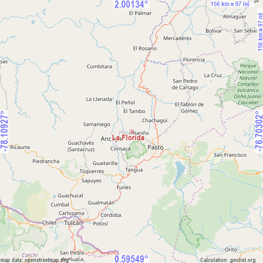
La Florida GPS coordinates[2]
1° 17' 54.636" North, 77° 24' 22.104" West
| Map corner | latitude | longitude |
|---|---|---|
| Upper-left | 2.00134°, | -78.10927° |
| Center: | 1.29851°, | -77.40614° |
| Lower-right: | 0.59549°, | -76.70302° |
| Map W x H: | 156.3×156.3 km | = 97.1×97.1mi |
| max Lat: | 13.38166° ⇑95.1% North |
| La Florida: | 1.29851° |
| min Lat: | ⇓4.9% South -4.21528° |
| min Long | La Florida | max Long |
| -81.70636° | -77.40614° | -67.06996° |
| W 4.3%⇐ | ⇒95.7% E |
Elevation
Elevation of La Florida is 2185 m = 7169 ft, and this is 1035.7 m = 3398 ft above average elevation for this country.
| Max E: |
3342 m = 10965 ft | 16% |
| La Florida | 2185 m 7169 ft | |
| Avg. | 1149.3 m = 3771 ft | |
Min E: |
1 m = 3 ft | 84% |
See also: Colombia elevation on elevation.city.
Geographical zone
La Florida is located in North Torrid zone (between Equator and Tropic of Cancer). Distance of Equator is 144.4 km =89.7 mi to South.| Distance of | km | miles | from La Florida |
|---|---|---|---|
| North Pole | 9862.7 | 6128.4 | to North |
| Arctic Circle | 7256.8 | 4509.2 | to North |
| Tropic Cancer | 2461.5 | 1529.5 | to North |
| Equator | 144.4 | 89.7 | to South |


Nearby cities:
15 places around La Florida: (largest is in red/bold)
• Ancuya
12.6 km =7.8 mi,  251°
251°
• Chachagüí
15.2 km =9.4 mi,  63°
63°
• Consacá
12 km =7.5 mi,  213°
213°
• El Peñol
17.7 km =11 mi,  347°
347°
• El Tambo
12.3 km =7.6 mi,  7°
7°
• Linares
14.3 km =8.9 mi,  294°
294°
• Nariño
5.5 km =3.4 mi,  99°
99°
• Olaya Herrera
11 km =6.8 mi,  239°
239°
• Pasto
16.8 km =10.4 mi,  124°
124°
• Providencia
22.2 km =13.8 mi, 252°
• Puerres
19.4 km =12.1 mi,  126°
126°
• Samaniego
21.5 km =13.4 mi,  281°
281°
• Sandoná
7.1 km =4.4 mi,  259°
259°
• Tangua
22.7 km =14.1 mi,  176°
176°
• Yacuanquer
20.3 km =12.6 mi, 178°
Sources, notices
• [Note1] Compared only with cities in Colombia existing in our database
• [Src1] Map data: © OpenStreetMap contributors (CC-BY-SA)
• [Src2] Other city data from geonames.org with taken over terms of usage.
• [Src3] Geographical zone / Annual Mean Temperature by Robert A. Rohde @ Wikipedia
