Cumbitara geodata
Cumbitara (Nariño) is a seat of a second-order administrative division; located in Colombia in America/Bogota (GMT-5) time zone. With population of 1,091 people, there are 937 cities with bigger population in this country. Compared to other cities in Colombia, 92.4% of cities are located further ↑North; 97.4% of cities are located further →East and 68.3% of cities have lower elevation than Cumbitara. Note1


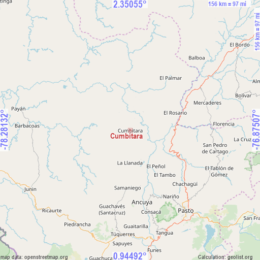
Cumbitara GPS coordinates[2]
1° 38' 52.296" North, 77° 34' 41.484" West
| Map corner | latitude | longitude |
|---|---|---|
| Upper-left | 2.35055°, | -78.28132° |
| Center: | 1.64786°, | -77.57819° |
| Lower-right: | 0.94492°, | -76.87507° |
| Map W x H: | 156.3×156.3 km | = 97.1×97.1mi |
| max Lat: | 13.38166° ⇑92.4% North |
| Cumbitara: | 1.64786° |
| min Lat: | ⇓7.6% South -4.21528° |
| min Long | Cumbitara | max Long |
| -81.70636° | -77.57819° | -67.06996° |
| W 2.6%⇐ | ⇒97.4% E |
Elevation
Elevation of Cumbitara is 1683 m = 5522 ft, and this is 533.7 m = 1751 ft above average elevation for this country.
| Max E: |
3342 m = 10965 ft | 31.7% |
| Cumbitara | 1683 m 5522 ft | |
| Avg. | 1149.3 m = 3771 ft | |
Min E: |
1 m = 3 ft | 68.3% |
See also: Colombia elevation on elevation.city.
Geographical zone
Cumbitara is located in North Torrid zone (between Equator and Tropic of Cancer). Distance of Equator is 183.2 km =113.8 mi to South.| Distance of | km | miles | from Cumbitara |
|---|---|---|---|
| North Pole | 9823.8 | 6104.2 | to North |
| Arctic Circle | 7217.9 | 4485 | to North |
| Tropic Cancer | 2422.7 | 1505.4 | to North |
| Equator | 183.2 | 113.8 | to South |


Nearby cities:
15 places around Cumbitara: (largest is in red/bold)
• Ancuya
43.4 km =27 mi,  170°
170°
• El Peñol
26.5 km =16.5 mi,  144°
144°
• El Rosario
29.1 km =18.1 mi,  68°
68°
• El Tambo
33.8 km =21 mi, 142°
• La Florida
43.3 km =26.9 mi,  153°
153°
• La Llanada
19.4 km =12.1 mi,  180°
180°
• Linares
33.6 km =20.9 mi, 169°
• Policarpa
13.4 km =8.3 mi,  99°
99°
• Providencia
15.4 km =9.6 mi,  124°
124°
• Samaniego
34.5 km =21.4 mi, 183°
• San Lorenzo
43.4 km =27 mi,  111°
111°
• Sandoná
42 km =26.1 mi,  163°
163°
• Santacruz
37.9 km =23.5 mi, 111°
• Sotomayor
18.2 km =11.3 mi, 159°
• Taminango
34.2 km =21.3 mi, 104°
Sources, notices
• [Note1] Compared only with cities in Colombia existing in our database
• [Src1] Map data: © OpenStreetMap contributors (CC-BY-SA)
• [Src2] Other city data from geonames.org with taken over terms of usage.
• [Src3] Geographical zone / Annual Mean Temperature by Robert A. Rohde @ Wikipedia
