Consacá geodata
Consacá (Nariño) is a seat of a second-order administrative division; located in Colombia in America/Bogota (GMT-5) time zone. With population of 2,239 people, there are 770 cities with bigger population in this country. Compared to other cities in Colombia, 96.1% of cities are located further ↑North; 96.2% of cities are located further →East and 67.4% of cities have lower elevation than Consacá. Note1


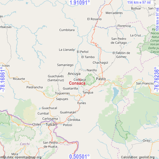
Consacá GPS coordinates[2]
1° 12' 28.98" North, 77° 27' 55.728" West
| Map corner | latitude | longitude |
|---|---|---|
| Upper-left | 1.91091°, | -78.16861° |
| Center: | 1.20805°, | -77.46548° |
| Lower-right: | 0.50501°, | -76.76236° |
| Map W x H: | 156.3×156.3 km | = 97.1×97.1mi |
| max Lat: | 13.38166° ⇑96.1% North |
| Consacá: | 1.20805° |
| min Lat: | ⇓3.9% South -4.21528° |
| min Long | Consacá | max Long |
| -81.70636° | -77.46548° | -67.06996° |
| W 3.8%⇐ | ⇒96.2% E |
Elevation
Elevation of Consacá is 1660 m = 5446 ft, and this is 510.7 m = 1676 ft above average elevation for this country.
| Max E: |
3342 m = 10965 ft | 32.6% |
| Consacá | 1660 m 5446 ft | |
| Avg. | 1149.3 m = 3771 ft | |
Min E: |
1 m = 3 ft | 67.4% |
See also: Colombia elevation on elevation.city.
Geographical zone
Consacá is located in North Torrid zone (between Equator and Tropic of Cancer). Distance of Equator is 134.3 km =83.5 mi to South.| Distance of | km | miles | from Consacá |
|---|---|---|---|
| North Pole | 9872.7 | 6134.6 | to North |
| Arctic Circle | 7266.9 | 4515.4 | to North |
| Tropic Cancer | 2471.6 | 1535.8 | to North |
| Equator | 134.3 | 83.5 | to South |


Nearby cities:
15 places around Consacá: (largest is in red/bold)
• Ancuya
8.2 km =5.1 mi,  318°
318°
• Guaitarilla
12.6 km =7.8 mi,  227°
227°
• Imués
17.4 km =10.8 mi,  191°
191°
• La Florida
12 km =7.5 mi,  33°
33°
• Linares
17.1 km =10.6 mi,  337°
337°
• Nariño
15.1 km =9.4 mi,  52°
52°
• Olaya Herrera
5.3 km =3.3 mi,  327°
327°
• Ospina
19.9 km =12.4 mi,  213°
213°
• Pasto
20.5 km =12.7 mi,  88°
88°
• Providencia
15 km =9.3 mi,  283°
283°
• Samaniego
20.5 km =12.7 mi, 315°
• Sandoná
8.7 km =5.4 mi,  357°
357°
• Tangua
14.8 km =9.2 mi,  148°
148°
• Túquerres
21.7 km =13.5 mi, 231°
• Yacuanquer
12.5 km =7.8 mi, 145°
Sources, notices
• [Note1] Compared only with cities in Colombia existing in our database
• [Src1] Map data: © OpenStreetMap contributors (CC-BY-SA)
• [Src2] Other city data from geonames.org with taken over terms of usage.
• [Src3] Geographical zone / Annual Mean Temperature by Robert A. Rohde @ Wikipedia
