Mercaderes geodata
Mercaderes (Cauca) is a populated place; located in Colombia in America/Bogota (GMT-5) time zone. With population of 4,684 people, there are 536 cities with bigger population in this country. Compared to other cities in Colombia, 91.4% of cities are located further ↑North; 93.9% of cities are located further →East and 50.3% of cities have lower elevation than Mercaderes. Note1


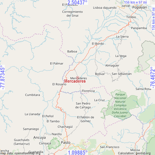
Mercaderes GPS coordinates[2]
1° 48' 6.3" North, 77° 10' 13.152" West
| Map corner | latitude | longitude |
|---|---|---|
| Upper-left | 2.50437°, | -77.87345° |
| Center: | 1.80175°, | -77.17032° |
| Lower-right: | 1.09885°, | -76.4672° |
| Map W x H: | 156.3×156.3 km | = 97.1×97.1mi |
| max Lat: | 13.38166° ⇑91.4% North |
| Mercaderes: | 1.80175° |
| min Lat: | ⇓8.6% South -4.21528° |
| min Long | Mercaderes | max Long |
| -81.70636° | -77.17032° | -67.06996° |
| W 6.1%⇐ | ⇒93.9% E |
Elevation
Elevation of Mercaderes is 1132 m = 3714 ft, and this is 17.3 m = 57 ft below average elevation for this country.
| Max E: |
3342 m = 10965 ft | 49.7% |
| Avg. | 1149.3 m = 3771 ft | |
| Mercaderes | 1132 m = 3714 ft | |
Min E: |
1 m = 3 ft | 50.3% |
See also: Colombia elevation on elevation.city.
Geographical zone
Mercaderes is located in North Torrid zone (between Equator and Tropic of Cancer). Distance of Equator is 200.3 km =124.5 mi to South.| Distance of | km | miles | from Mercaderes |
|---|---|---|---|
| North Pole | 9806.7 | 6093.6 | to North |
| Arctic Circle | 7200.8 | 4474.4 | to North |
| Tropic Cancer | 2405.6 | 1494.8 | to North |
| Equator | 200.3 | 124.5 | to South |


Nearby cities:
15 places around Mercaderes: (largest is in red/bold)
• Balboa
27.2 km =16.9 mi,  349°
349°
• Belén
26.4 km =16.4 mi,  150°
150°
• Bolívar
22.8 km =14.2 mi,  79°
79°
• Cartago
28.4 km =17.6 mi,  168°
168°
• El Rosario
19.4 km =12.1 mi,  250°
250°
• Florencia
17 km =10.6 mi,  140°
140°
• Génova
24.3 km =15.1 mi, 136°
• La Cruz
31.3 km =19.4 mi, 135°
• La Unión
22.4 km =13.9 mi, 168°
• Leiva
21.2 km =13.2 mi,  314°
314°
• Patía
32.5 km =20.2 mi,  23°
23°
• San Lorenzo
33.6 km =20.9 mi,  188°
188°
• San Pablo
22.6 km =14 mi,  129°
129°
• Santacruz
32.9 km =20.4 mi,  198°
198°
• Taminango
28.5 km =17.7 mi,  205°
205°
Sources, notices
• [Note1] Compared only with cities in Colombia existing in our database
• [Src1] Map data: © OpenStreetMap contributors (CC-BY-SA)
• [Src2] Other city data from geonames.org with taken over terms of usage.
• [Src3] Geographical zone / Annual Mean Temperature by Robert A. Rohde @ Wikipedia
