Condoto geodata
Condoto (Chocó) is a seat of a second-order administrative division; located in Colombia in America/Bogota (GMT-5) time zone. With population of 9,897 people, there are 308 cities with bigger population in this country. Compared to other cities in Colombia, 59.6% of cities are located further ↑North; 89.1% of cities are located further →East and 84.9% of cities have higher elevation than Condoto. Note1


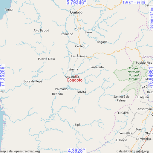
Condoto GPS coordinates[2]
5° 5' 36.636" North, 76° 38' 59.028" West
| Map corner | latitude | longitude |
|---|---|---|
| Upper-left | 5.79346°, | -77.35286° |
| Center: | 5.09351°, | -76.64973° |
| Lower-right: | 4.3928°, | -75.94661° |
| Map W x H: | 155.7×155.7 km | = 96.7×96.7mi |
| max Lat: | 13.38166° ⇑59.6% North |
| Condoto: | 5.09351° |
| min Lat: | ⇓40.4% South -4.21528° |
| min Long | Condoto | max Long |
| -81.70636° | -76.64973° | -67.06996° |
| W 10.9%⇐ | ⇒89.1% E |
Elevation
Elevation of Condoto is 62 m = 203 ft, and this is 1087.3 m = 3567 ft below average elevation for this country.
| Max E: |
3342 m = 10965 ft | 84.9% |
| Avg. | 1149.3 m = 3771 ft | |
| Condoto | 62 m = 203 ft | |
Min E: |
1 m = 3 ft | 15.1% |
See also: Colombia elevation on elevation.city.
Geographical zone
Condoto is located in North Torrid zone (between Equator and Tropic of Cancer). Distance of Equator is 566.3 km =351.9 mi to South.| Distance of | km | miles | from Condoto |
|---|---|---|---|
| North Pole | 9440.7 | 5866.2 | to North |
| Arctic Circle | 6834.8 | 4246.9 | to North |
| Tropic Cancer | 2039.6 | 1267.3 | to North |
| Equator | 566.3 | 351.9 | to South |


Nearby cities:
15 places around Condoto: (largest is in red/bold)
• Bagadó
43.9 km =27.3 mi,  36°
36°
• Cértegui
31.2 km =19.4 mi,  9°
9°
• El Cantón de San Pablo
28.7 km =17.8 mi,  341°
341°
• Istmina
8.4 km =5.2 mi,  333°
333°
• Lloró
46.1 km =28.6 mi, 13°
• Managrú
28.4 km =17.6 mi, 342°
• Nóvita
16.2 km =10.1 mi,  162°
162°
• Paimadó
44.5 km =27.7 mi,  346°
346°
• Puerto Meluk
34.8 km =21.6 mi,  294°
294°
• San José del Palmar
51 km =31.7 mi,  115°
115°
• Santa Rita
21 km =13 mi,  61°
61°
• Sipí
48.9 km =30.4 mi,  179°
179°
• Tadó
21.4 km =13.3 mi,  26°
26°
• Yuto
48.7 km =30.3 mi,  1°
1°
• Ánimas
20.6 km =12.8 mi, 5°
Sources, notices
• [Note1] Compared only with cities in Colombia existing in our database
• [Src1] Map data: © OpenStreetMap contributors (CC-BY-SA)
• [Src2] Other city data from geonames.org with taken over terms of usage.
• [Src3] Geographical zone / Annual Mean Temperature by Robert A. Rohde @ Wikipedia
