Bagadó geodata
Bagadó (Chocó) is a seat of a second-order administrative division; located in Colombia in America/Bogota (GMT-5) time zone. With population of 4,561 people, there are 540 cities with bigger population in this country. Compared to other cities in Colombia, 52.1% of cities are located further ↑North; 85.9% of cities are located further →East and 80.6% of cities have higher elevation than Bagadó. Note1


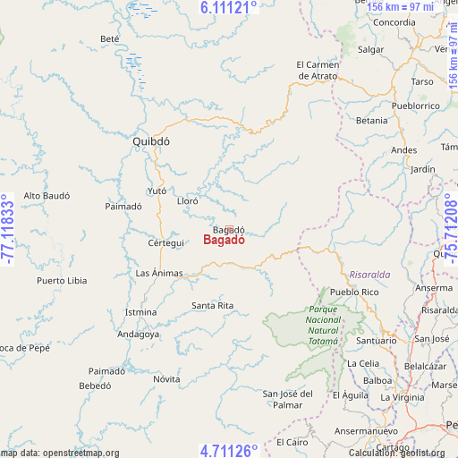
Bagadó GPS coordinates[2]
5° 24' 41.904" North, 76° 24' 54.72" West
| Map corner | latitude | longitude |
|---|---|---|
| Upper-left | 6.11121°, | -77.11833° |
| Center: | 5.41164°, | -76.4152° |
| Lower-right: | 4.71126°, | -75.71208° |
| Map W x H: | 155.7×155.7 km | = 96.7×96.7mi |
| max Lat: | 13.38166° ⇑52.1% North |
| Bagadó: | 5.41164° |
| min Lat: | ⇓47.9% South -4.21528° |
| min Long | Bagadó | max Long |
| -81.70636° | -76.4152° | -67.06996° |
| W 14.1%⇐ | ⇒85.9% E |
Elevation
Elevation of Bagadó is 109 m = 358 ft, and this is 1040.3 m = 3413 ft below average elevation for this country.
| Max E: |
3342 m = 10965 ft | 80.6% |
| Avg. | 1149.3 m = 3771 ft | |
| Bagadó | 109 m = 358 ft | |
Min E: |
1 m = 3 ft | 19.4% |
See also: Colombia elevation on elevation.city.
Geographical zone
Bagadó is located in North Torrid zone (between Equator and Tropic of Cancer). Distance of Equator is 601.7 km =373.9 mi to South.| Distance of | km | miles | from Bagadó |
|---|---|---|---|
| North Pole | 9405.3 | 5844.2 | to North |
| Arctic Circle | 6799.5 | 4225 | to North |
| Tropic Cancer | 2004.2 | 1245.4 | to North |
| Equator | 601.7 | 373.9 | to South |


Nearby cities:
15 places around Bagadó: (largest is in red/bold)
• Condoto
43.9 km =27.3 mi,  216°
216°
• Cértegui
21.4 km =13.3 mi,  257°
257°
• El Cantón de San Pablo
35.9 km =22.3 mi, 256°
• Istmina
40.8 km =25.4 mi,  226°
226°
• La Merced
58.7 km =36.5 mi,  91°
91°
• Lloró
17.6 km =10.9 mi,  302°
302°
• Managrú
35.6 km =22.1 mi, 256°
• Nóvita
55 km =34.2 mi,  202°
202°
• Paimadó
36.9 km =22.9 mi,  282°
282°
• Pueblo Rico
47.5 km =29.5 mi,  116°
116°
• Quibdó
41.2 km =25.6 mi,  319°
319°
• Santa Rita
26.5 km =16.5 mi, 196°
• Tadó
23.2 km =14.4 mi, 225°
• Yuto
27.8 km =17.3 mi, 298°
• Ánimas
28.1 km =17.5 mi,  238°
238°
Sources, notices
• [Note1] Compared only with cities in Colombia existing in our database
• [Src1] Map data: © OpenStreetMap contributors (CC-BY-SA)
• [Src2] Other city data from geonames.org with taken over terms of usage.
• [Src3] Geographical zone / Annual Mean Temperature by Robert A. Rohde @ Wikipedia
