Lloró geodata
Lloró (Chocó) is a seat of a second-order administrative division; located in Colombia in America/Bogota (GMT-5) time zone. With population of 2,651 people, there are 721 cities with bigger population in this country. Compared to other cities in Colombia, 50.7% of cities are located further ↑North; 87.5% of cities are located further →East and 82.2% of cities have higher elevation than Lloró. Note1


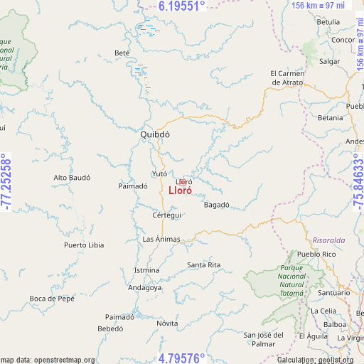
Lloró GPS coordinates[2]
5° 29' 45.78" North, 76° 32' 58.02" West
| Map corner | latitude | longitude |
|---|---|---|
| Upper-left | 6.19551°, | -77.25258° |
| Center: | 5.49605°, | -76.54945° |
| Lower-right: | 4.79576°, | -75.84633° |
| Map W x H: | 155.6×155.6 km | = 96.7×96.7mi |
| max Lat: | 13.38166° ⇑50.7% North |
| Lloró: | 5.49605° |
| min Lat: | ⇓49.3% South -4.21528° |
| min Long | Lloró | max Long |
| -81.70636° | -76.54945° | -67.06996° |
| W 12.5%⇐ | ⇒87.5% E |
Elevation
Elevation of Lloró is 90 m = 295 ft, and this is 1059.3 m = 3475 ft below average elevation for this country.
| Max E: |
3342 m = 10965 ft | 82.2% |
| Avg. | 1149.3 m = 3771 ft | |
| Lloró | 90 m = 295 ft | |
Min E: |
1 m = 3 ft | 17.8% |
See also: Colombia elevation on elevation.city.
Geographical zone
Lloró is located in North Torrid zone (between Equator and Tropic of Cancer). Distance of Equator is 611.1 km =379.7 mi to South.| Distance of | km | miles | from Lloró |
|---|---|---|---|
| North Pole | 9396 | 5838.4 | to North |
| Arctic Circle | 6790.1 | 4219.2 | to North |
| Tropic Cancer | 1994.8 | 1239.5 | to North |
| Equator | 611.1 | 379.7 | to South |


Nearby cities:
15 places around Lloró: (largest is in red/bold)
• Bagadó
17.6 km =10.9 mi,  122°
122°
• Condoto
46.1 km =28.6 mi,  193°
193°
• Cértegui
15.2 km =9.4 mi,  203°
203°
• El Cantón de San Pablo
26.7 km =16.6 mi,  229°
229°
• Istmina
40.2 km =25 mi, 201°
• Managrú
26.5 km =16.5 mi, 228°
• Nóvita
60.5 km =37.6 mi, 185°
• Paimadó
21.2 km =13.2 mi,  266°
266°
• Pie de Pató
47.1 km =29.3 mi, 272°
• Puerto Meluk
52.7 km =32.7 mi, 234°
• Quibdó
24.9 km =15.5 mi,  331°
331°
• Santa Rita
35.5 km =22.1 mi,  168°
168°
• Tadó
25.6 km =15.9 mi,  183°
183°
• Yuto
10.3 km =6.4 mi,  292°
292°
• Ánimas
25.9 km =16.1 mi, 200°
Sources, notices
• [Note1] Compared only with cities in Colombia existing in our database
• [Src1] Map data: © OpenStreetMap contributors (CC-BY-SA)
• [Src2] Other city data from geonames.org with taken over terms of usage.
• [Src3] Geographical zone / Annual Mean Temperature by Robert A. Rohde @ Wikipedia
