Yuto geodata
Yuto (Chocó) is a seat of a second-order administrative division; located in Colombia in America/Bogota (GMT-5) time zone. In our database, there are 1053 cities with bigger population. Compared to other cities in Colombia, 50.2% of cities are located further ↓South; 88.8% of cities are located further →East and 85.5% of cities have higher elevation than Yuto. Note1


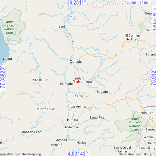
Yuto GPS coordinates[2]
5° 31' 54.048" North, 76° 38' 6.432" West
| Map corner | latitude | longitude |
|---|---|---|
| Upper-left | 6.2311°, | -77.33825° |
| Center: | 5.53168°, | -76.63512° |
| Lower-right: | 4.83143°, | -75.932° |
| Map W x H: | 155.6×155.6 km | = 96.7×96.7mi |
| max Lat: | 13.38166° ⇑49.8% North |
| Yuto: | 5.53168° |
| min Lat: | ⇓50.2% South -4.21528° |
| min Long | Yuto | max Long |
| -81.70636° | -76.63512° | -67.06996° |
| W 11.2%⇐ | ⇒88.8% E |
Elevation
Elevation of Yuto is 53 m = 174 ft, and this is 1096.3 m = 3597 ft below average elevation for this country.
| Max E: |
3342 m = 10965 ft | 85.5% |
| Avg. | 1149.3 m = 3771 ft | |
| Yuto | 53 m = 174 ft | |
Min E: |
1 m = 3 ft | 14.5% |
See also: Colombia elevation on elevation.city.
Geographical zone
Yuto is located in North Torrid zone (between Equator and Tropic of Cancer). Distance of Equator is 615.1 km =382.2 mi to South.| Distance of | km | miles | from Yuto |
|---|---|---|---|
| North Pole | 9392 | 5835.9 | to North |
| Arctic Circle | 6786.1 | 4216.7 | to North |
| Tropic Cancer | 1990.9 | 1237.1 | to North |
| Equator | 615.1 | 382.2 | to South |


Nearby cities:
15 places around Yuto: (largest is in red/bold)
• Bagadó
27.8 km =17.3 mi,  118°
118°
• Beté
53.9 km =33.5 mi,  342°
342°
• Condoto
48.7 km =30.3 mi,  181°
181°
• Cértegui
18.2 km =11.3 mi,  169°
169°
• El Cantón de San Pablo
23.9 km =14.9 mi,  206°
206°
• Istmina
41.6 km =25.8 mi,  187°
187°
• Lloró
10.3 km =6.4 mi,  112°
112°
• Managrú
24 km =14.9 mi, 205°
• Paimadó
12.9 km =8 mi,  245°
245°
• Pie de Pató
37.6 km =23.4 mi,  267°
267°
• Puerto Meluk
48 km =29.8 mi,  224°
224°
• Quibdó
18 km =11.2 mi,  351°
351°
• Santa Rita
42.2 km =26.2 mi,  156°
156°
• Tadó
30.5 km =19 mi, 165°
• Ánimas
28.2 km =17.5 mi, 179°
Sources, notices
• [Note1] Compared only with cities in Colombia existing in our database
• [Src1] Map data: © OpenStreetMap contributors (CC-BY-SA)
• [Src2] Other city data from geonames.org with taken over terms of usage.
• [Src3] Geographical zone / Annual Mean Temperature by Robert A. Rohde @ Wikipedia
