Arroyohondo geodata
Arroyohondo (Bolívar) is a seat of a second-order administrative division; located in Colombia in America/Bogota (GMT-5) time zone. With population of 3,622 people, there are 619 cities with bigger population in this country. Compared to other cities in Colombia, 93.9% of cities are located further ↓South; 54.7% of cities are located further →East and 89.8% of cities have higher elevation than Arroyohondo. Note1


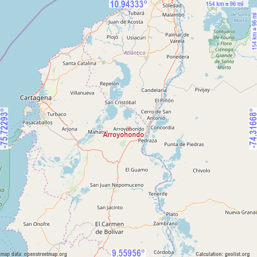
Arroyohondo GPS coordinates[2]
10° 15' 7.92" North, 75° 1' 11.28" West
| Map corner | latitude | longitude |
|---|---|---|
| Upper-left | 10.94333°, | -75.72293° |
| Center: | 10.2522°, | -75.0198° |
| Lower-right: | 9.55956°, | -74.31668° |
| Map W x H: | 153.9×153.9 km | = 95.6×95.6mi |
| max Lat: | 13.38166° ⇑6.1% North |
| Arroyohondo: | 10.2522° |
| min Lat: | ⇓93.9% South -4.21528° |
| min Long | Arroyohondo | max Long |
| -81.70636° | -75.0198° | -67.06996° |
| W 45.3%⇐ | ⇒54.7% E |
Elevation
Elevation of Arroyohondo is 30 m = 98 ft, and this is 1119.3 m = 3672 ft below average elevation for this country.
| Max E: |
3342 m = 10965 ft | 89.8% |
| Avg. | 1149.3 m = 3771 ft | |
| Arroyohondo | 30 m = 98 ft | |
Min E: |
1 m = 3 ft | 10.2% |
See also: Colombia elevation on elevation.city.
Geographical zone
Arroyohondo is located in North Torrid zone (between Equator and Tropic of Cancer). Distance of Equator is 1139.9 km =708.3 mi to South.| Distance of | km | miles | from Arroyohondo |
|---|---|---|---|
| North Pole | 8867.1 | 5509.8 | to North |
| Arctic Circle | 6261.2 | 3890.5 | to North |
| Tropic Cancer | 1466 | 910.9 | to North |
| Equator | 1139.9 | 708.3 | to South |


Nearby cities:
15 places around Arroyohondo: (largest is in red/bold)
• Calamar
11.4 km =7.1 mi,  89°
89°
• Campo de la Cruz
20.4 km =12.7 mi,  46°
46°
• Candelaria
27.6 km =17.1 mi,  33°
33°
• Cerro de San Antonio
18.4 km =11.4 mi,  63°
63°
• Concordia
20.4 km =12.7 mi, 88°
• El Guamo
25 km =15.5 mi,  168°
168°
• El Piñón
27.2 km =16.9 mi, 51°
• Mahates
18.7 km =11.6 mi,  263°
263°
• Manatí
22.5 km =14 mi,  17°
17°
• Pedraza
13.5 km =8.4 mi,  122°
122°
• San Cristóbal
16.7 km =10.4 mi,  342°
342°
• San Estanislao
21.7 km =13.5 mi,  318°
318°
• Santa Lucía
10.3 km =6.4 mi,  39°
39°
• Soplaviento
20.5 km =12.7 mi, 319°
• Suan
17.7 km =11 mi, 59°
Sources, notices
• [Note1] Compared only with cities in Colombia existing in our database
• [Src1] Map data: © OpenStreetMap contributors (CC-BY-SA)
• [Src2] Other city data from geonames.org with taken over terms of usage.
• [Src3] Geographical zone / Annual Mean Temperature by Robert A. Rohde @ Wikipedia
