Santa Lucía geodata
Santa Lucía (Atlántico) is a seat of a second-order administrative division; located in Colombia in America/Bogota (GMT-5) time zone. With population of 15,760 people, there are 217 cities with bigger population in this country. Compared to other cities in Colombia, 94.4% of cities are located further ↓South; 53.2% of cities are located further →East and 97.1% of cities have higher elevation than Santa Lucía. Note1


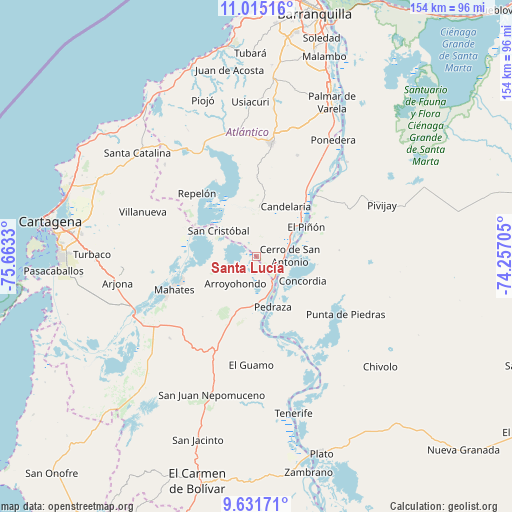
Santa Lucía GPS coordinates[2]
10° 19' 27.12" North, 74° 57' 36.612" West
| Map corner | latitude | longitude |
|---|---|---|
| Upper-left | 11.01516°, | -75.6633° |
| Center: | 10.3242°, | -74.96017° |
| Lower-right: | 9.63171°, | -74.25705° |
| Map W x H: | 153.8×153.8 km | = 95.6×95.6mi |
| max Lat: | 13.38166° ⇑5.6% North |
| Santa Lucía: | 10.3242° |
| min Lat: | ⇓94.4% South -4.21528° |
| min Long | Santa Lucía | max Long |
| -81.70636° | -74.96017° | -67.06996° |
| W 46.8%⇐ | ⇒53.2% E |
Elevation
Elevation of Santa Lucía is 9 m = 30 ft, and this is 1140.3 m = 3741 ft below average elevation for this country.
| Max E: |
3342 m = 10965 ft | 97.1% |
| Avg. | 1149.3 m = 3771 ft | |
| Santa Lucía | 9 m = 30 ft | |
Min E: |
1 m = 3 ft | 2.9% |
See also: Colombia elevation on elevation.city.
Geographical zone
Santa Lucía is located in North Torrid zone (between Equator and Tropic of Cancer). Distance of Equator is 1147.9 km =713.3 mi to South.| Distance of | km | miles | from Santa Lucía |
|---|---|---|---|
| North Pole | 8859.1 | 5504.8 | to North |
| Arctic Circle | 6253.2 | 3885.6 | to North |
| Tropic Cancer | 1458 | 906 | to North |
| Equator | 1147.9 | 713.3 | to South |


Nearby cities:
15 places around Santa Lucía: (largest is in red/bold)
• Arroyohondo
10.3 km =6.4 mi,  219°
219°
• Calamar
9.3 km =5.8 mi,  148°
148°
• Campo de la Cruz
10.3 km =6.4 mi,  54°
54°
• Candelaria
17.4 km =10.8 mi,  30°
30°
• Cerro de San Antonio
9.9 km =6.2 mi,  88°
88°
• Concordia
15.7 km =9.8 mi,  118°
118°
• El Piñón
17.3 km =10.7 mi,  59°
59°
• Manatí
13.5 km =8.4 mi,  0°
0°
• Pedraza
16 km =9.9 mi,  162°
162°
• Repelón
26.2 km =16.3 mi,  316°
316°
• Salamina
25.9 km =16.1 mi,  44°
44°
• San Cristóbal
14 km =8.7 mi,  304°
304°
• San Estanislao
22.5 km =14 mi,  291°
291°
• Soplaviento
21.2 km =13.2 mi, 291°
• Suan
8.8 km =5.5 mi,  83°
83°
Sources, notices
• [Note1] Compared only with cities in Colombia existing in our database
• [Src1] Map data: © OpenStreetMap contributors (CC-BY-SA)
• [Src2] Other city data from geonames.org with taken over terms of usage.
• [Src3] Geographical zone / Annual Mean Temperature by Robert A. Rohde @ Wikipedia
