Andes geodata
Andes (Antioquia) is a populated place; located in Colombia in America/Bogota (GMT-5) time zone. With population of 16,419 people, there are 210 cities with bigger population in this country. Compared to other cities in Colombia, 53.1% of cities are located further ↓South; 77.5% of cities are located further →East and 54.6% of cities have lower elevation than Andes. Note1


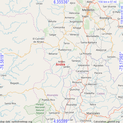
Andes GPS coordinates[2]
5° 39' 21.96" North, 75° 52' 43.572" West
| Map corner | latitude | longitude |
|---|---|---|
| Upper-left | 6.35536°, | -76.5819° |
| Center: | 5.6561°, | -75.87877° |
| Lower-right: | 4.95599°, | -75.17565° |
| Map W x H: | 155.6×155.6 km | = 96.7×96.7mi |
| max Lat: | 13.38166° ⇑46.9% North |
| Andes: | 5.6561° |
| min Lat: | ⇓53.1% South -4.21528° |
| min Long | Andes | max Long |
| -81.70636° | -75.87877° | -67.06996° |
| W 22.5%⇐ | ⇒77.5% E |
Elevation
Elevation of Andes is 1282 m = 4206 ft, and this is 132.7 m = 435 ft above average elevation for this country.
| Max E: |
3342 m = 10965 ft | 45.4% |
| Andes | 1282 m 4206 ft | |
| Avg. | 1149.3 m = 3771 ft | |
Min E: |
1 m = 3 ft | 54.6% |
See also: Colombia elevation on elevation.city.
Geographical zone
Andes is located in North Torrid zone (between Equator and Tropic of Cancer). Distance of Equator is 628.9 km =390.8 mi to South.| Distance of | km | miles | from Andes |
|---|---|---|---|
| North Pole | 9378.2 | 5827.3 | to North |
| Arctic Circle | 6772.3 | 4208.1 | to North |
| Tropic Cancer | 1977 | 1228.5 | to North |
| Equator | 628.9 | 390.8 | to South |


Nearby cities:
15 places around Andes: (largest is in red/bold)
• Betania
14.8 km =9.2 mi,  312°
312°
• Caramanta
28.7 km =17.8 mi,  114°
114°
• Ciudad Bolívar
27.3 km =17 mi,  323°
323°
• Hispania
16.2 km =10.1 mi,  348°
348°
• Jardín
9.1 km =5.7 mi,  134°
134°
• Jericó
18.3 km =11.4 mi,  34°
34°
• La Merced
28.3 km =17.6 mi,  181°
181°
• La Pintada
31.9 km =19.8 mi,  71°
71°
• Pueblorrico
15.7 km =9.8 mi,  15°
15°
• Riosucio
32.5 km =20.2 mi,  143°
143°
• Salgar
35.7 km =22.2 mi,  344°
344°
• Supía
33.9 km =21.1 mi, 131°
• Tarso
24 km =14.9 mi, 15°
• Támesis
18.3 km =11.4 mi,  87°
87°
• Valparaíso
28.5 km =17.7 mi,  99°
99°
Sources, notices
• [Note1] Compared only with cities in Colombia existing in our database
• [Src1] Map data: © OpenStreetMap contributors (CC-BY-SA)
• [Src2] Other city data from geonames.org with taken over terms of usage.
• [Src3] Geographical zone / Annual Mean Temperature by Robert A. Rohde @ Wikipedia
