Zarzal geodata
Zarzal (Valle del Cauca) is a seat of a second-order administrative division; located in Colombia in America/Bogota (GMT-5) time zone. With population of 28,761 people, there are 126 cities with bigger population in this country. Compared to other cities in Colombia, 73.1% of cities are located further ↑North; 81.4% of cities are located further →East and 57.5% of cities have higher elevation than Zarzal. Note1


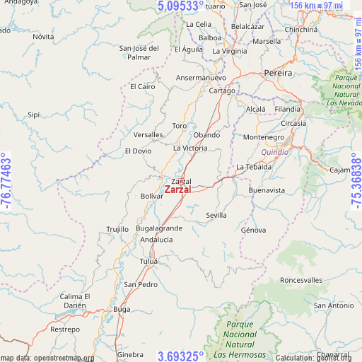
Zarzal GPS coordinates[2]
4° 23' 40.632" North, 76° 4' 17.4" West
| Map corner | latitude | longitude |
|---|---|---|
| Upper-left | 5.09533°, | -76.77463° |
| Center: | 4.39462°, | -76.0715° |
| Lower-right: | 3.69325°, | -75.36838° |
| Map W x H: | 155.9×155.9 km | = 96.9×96.9mi |
| max Lat: | 13.38166° ⇑73.1% North |
| Zarzal: | 4.39462° |
| min Lat: | ⇓26.9% South -4.21528° |
| min Long | Zarzal | max Long |
| -81.70636° | -76.0715° | -67.06996° |
| W 18.6%⇐ | ⇒81.4% E |
Elevation
Elevation of Zarzal is 921 m = 3022 ft, and this is 228.3 m = 749 ft below average elevation for this country.
| Max E: |
3342 m = 10965 ft | 57.5% |
| Avg. | 1149.3 m = 3771 ft | |
| Zarzal | 921 m = 3022 ft | |
Min E: |
1 m = 3 ft | 42.5% |
See also: Colombia elevation on elevation.city.
Geographical zone
Zarzal is located in North Torrid zone (between Equator and Tropic of Cancer). Distance of Equator is 488.6 km =303.6 mi to South.| Distance of | km | miles | from Zarzal |
|---|---|---|---|
| North Pole | 9518.4 | 5914.5 | to North |
| Arctic Circle | 6912.5 | 4295.2 | to North |
| Tropic Cancer | 2117.3 | 1315.6 | to North |
| Equator | 488.6 | 303.6 | to South |


Nearby cities:
15 places around Zarzal: (largest is in red/bold)
• Andalucía
27 km =16.8 mi,  202°
202°
• Bolívar
13.9 km =8.6 mi,  243°
243°
• Bugalagrande
22.3 km =13.9 mi, 204°
• Caicedonia
28 km =17.4 mi,  104°
104°
• El Dovio
22.2 km =13.8 mi,  304°
304°
• Génova
34.9 km =21.7 mi, 104°
• La Tebaida
32.1 km =19.9 mi,  78°
78°
• La Unión
15.8 km =9.8 mi,  347°
347°
• La Victoria
14.9 km =9.3 mi,  13°
13°
• Obando
22.9 km =14.2 mi,  28°
28°
• Roldanillo
9.4 km =5.8 mi,  282°
282°
• Sevilla
21.3 km =13.2 mi,  132°
132°
• Toro
24.2 km =15 mi,  357°
357°
• Trujillo
34.2 km =21.3 mi,  233°
233°
• Versalles
24.5 km =15.2 mi,  325°
325°
Sources, notices
• [Note1] Compared only with cities in Colombia existing in our database
• [Src1] Map data: © OpenStreetMap contributors (CC-BY-SA)
• [Src2] Other city data from geonames.org with taken over terms of usage.
• [Src3] Geographical zone / Annual Mean Temperature by Robert A. Rohde @ Wikipedia
