Génova geodata
Génova (Quindío) is a seat of a second-order administrative division; located in Colombia in America/Bogota (GMT-5) time zone. In our database, there are 1053 cities with bigger population. Compared to other cities in Colombia, 76.2% of cities are located further ↑North; 75.1% of cities are located further →East and 58.4% of cities have lower elevation than Génova. Note1


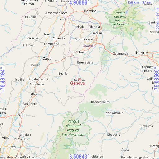
Génova GPS coordinates[2]
4° 12' 28.656" North, 75° 47' 19.716" West
| Map corner | latitude | longitude |
|---|---|---|
| Upper-left | 4.90886°, | -76.49194° |
| Center: | 4.20796°, | -75.78881° |
| Lower-right: | 3.50643°, | -75.08569° |
| Map W x H: | 155.9×155.9 km | = 96.9×96.9mi |
| max Lat: | 13.38166° ⇑76.2% North |
| Génova: | 4.20796° |
| min Lat: | ⇓23.8% South -4.21528° |
| min Long | Génova | max Long |
| -81.70636° | -75.78881° | -67.06996° |
| W 24.9%⇐ | ⇒75.1% E |
Elevation
Elevation of Génova is 1426 m = 4678 ft, and this is 276.7 m = 908 ft above average elevation for this country.
| Max E: |
3342 m = 10965 ft | 41.6% |
| Génova | 1426 m 4678 ft | |
| Avg. | 1149.3 m = 3771 ft | |
Min E: |
1 m = 3 ft | 58.4% |
See also: Colombia elevation on elevation.city.
Geographical zone
Génova is located in North Torrid zone (between Equator and Tropic of Cancer). Distance of Equator is 467.9 km =290.7 mi to South.| Distance of | km | miles | from Génova |
|---|---|---|---|
| North Pole | 9539.2 | 5927.4 | to North |
| Arctic Circle | 6933.3 | 4308.2 | to North |
| Tropic Cancer | 2138 | 1328.5 | to North |
| Equator | 467.9 | 290.7 | to South |


Nearby cities:
15 places around Génova: (largest is in red/bold)
• Anaime
43.5 km =27 mi,  61°
61°
• Andalucía
42.1 km =26.2 mi,  264°
264°
• Armenia
38.2 km =23.7 mi,  18°
18°
• Buenavista
17.8 km =11.1 mi, 18°
• Bugalagrande
40.7 km =25.3 mi,  270°
270°
• Caicedonia
14.5 km =9 mi,  343°
343°
• Calarcá
39.3 km =24.4 mi, 24°
• Córdoba
23.3 km =14.5 mi,  28°
28°
• Génova
12.3 km =7.6 mi,  11°
11°
• La Tebaida
27.2 km =16.9 mi,  0°
0°
• Montenegro
40.1 km =24.9 mi, 5°
• Pijao
16.8 km =10.4 mi, 33°
• Roncesvalles
29.9 km =18.6 mi,  137°
137°
• Sevilla
16.9 km =10.5 mi,  291°
291°
• Zarzal
37.6 km =23.4 mi,  303°
303°
Sources, notices
• [Note1] Compared only with cities in Colombia existing in our database
• [Src1] Map data: © OpenStreetMap contributors (CC-BY-SA)
• [Src2] Other city data from geonames.org with taken over terms of usage.
• [Src3] Geographical zone / Annual Mean Temperature by Robert A. Rohde @ Wikipedia
