San Diego geodata
San Diego (Cartago) is a populated place; located in Costa Rica in America/Costa_Rica (GMT-6) time zone. With population of 16,991 people, there are 35 cities with bigger population in this country. Compared to other cities in Costa Rica, 69.4% of cities are located further ↑North; 73.1% of cities are located further ←West and 85.8% of cities have lower elevation than San Diego. Note1


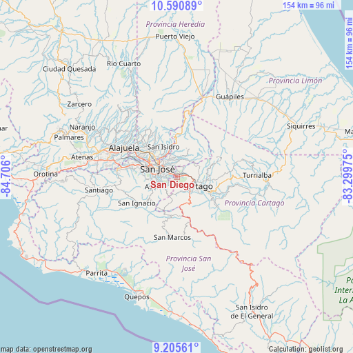
San Diego GPS coordinates[2]
9° 53' 56.328" North, 84° 0' 10.332" West
| Map corner | latitude | longitude |
|---|---|---|
| Upper-left | 10.59089°, | -84.706° |
| Center: | 9.89898°, | -84.00287° |
| Lower-right: | 9.20561°, | -83.29975° |
| Map W x H: | 154×154 km | = 95.7×95.7mi |
| max Lat: | 11.07377° ⇑69.4% North |
| San Diego: | 9.89898° |
| min Lat: | ⇓30.6% South 8.53305° |
| min Long | San Diego | max Long |
| -85.64748° | -84.00287° | -82.62185° |
| W 73.1%⇐ | ⇒26.9% E |
Elevation
Elevation of San Diego is 1275 m = 4183 ft, and this is 540 m = 1772 ft above average elevation for this country.
| Max E: |
1844 m = 6050 ft | 14.2% |
| San Diego | 1275 m 4183 ft | |
| Avg. | 735 m = 2411 ft | |
Min E: |
7 m = 23 ft | 85.8% |
See also: Costa Rica elevation on elevation.city.
Geographical zone
San Diego is located in North Torrid zone (between Equator and Tropic of Cancer). Distance of Equator is 1100.7 km =683.9 mi to South.| Distance of | km | miles | from San Diego |
|---|---|---|---|
| North Pole | 8906.4 | 5534.2 | to North |
| Arctic Circle | 6300.5 | 3914.9 | to North |
| Tropic Cancer | 1505.3 | 935.3 | to North |
| Equator | 1100.7 | 683.9 | to South |


Nearby cities:
15 places around San Diego: (largest is in red/bold)
• Concepción
3.8 km =2.4 mi,  4°
4°
• Curridabat
3.7 km =2.3 mi,  292°
292°
• Granadilla
4.3 km =2.7 mi,  338°
338°
• Guadalupe
8 km =5 mi,  312°
312°
• Ipís
7.7 km =4.8 mi,  351°
351°
• Patarrá
4.1 km =2.5 mi,  240°
240°
• Purral
7.2 km =4.5 mi, 335°
• Sabanilla
6.5 km =4 mi,  322°
322°
• San Miguel
7.1 km =4.4 mi, 244°
• San Pedro
6.2 km =3.9 mi,  301°
301°
• San Rafael Arriba
8.5 km =5.3 mi,  252°
252°
• San Vicente
8.4 km =5.2 mi, 324°
• San Vicente de Moravia
8.6 km =5.3 mi, 324°
• Tobosi
7.1 km =4.4 mi,  162°
162°
• Tres Ríos
1.9 km =1.2 mi,  63°
63°
Sources, notices
• [Note1] Compared only with cities in Costa Rica existing in our database
• [Src1] Map data: © OpenStreetMap contributors (CC-BY-SA)
• [Src2] Other city data from geonames.org with taken over terms of usage.
• [Src3] Geographical zone / Annual Mean Temperature by Robert A. Rohde @ Wikipedia
