San Miguel geodata
San Miguel (San José) is a populated place; located in Costa Rica in America/Costa_Rica (GMT-6) time zone. With population of 28,827 people, there are 14 cities with bigger population in this country. Compared to other cities in Costa Rica, 73.9% of cities are located further ↑North; 61.9% of cities are located further ←West and 79.9% of cities have lower elevation than San Miguel. Note1


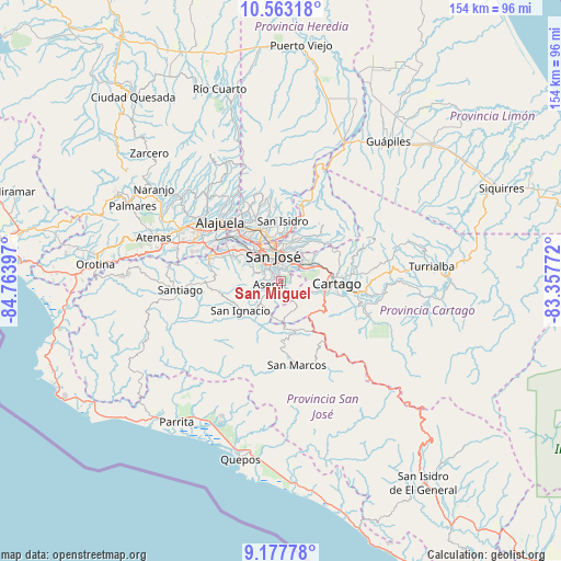
San Miguel GPS coordinates[2]
9° 52' 16.356" North, 84° 3' 39.024" West
| Map corner | latitude | longitude |
|---|---|---|
| Upper-left | 10.56318°, | -84.76397° |
| Center: | 9.87121°, | -84.06084° |
| Lower-right: | 9.17778°, | -83.35772° |
| Map W x H: | 154×154 km | = 95.7×95.7mi |
| max Lat: | 11.07377° ⇑73.9% North |
| San Miguel: | 9.87121° |
| min Lat: | ⇓26.1% South 8.53305° |
| min Long | San Miguel | max Long |
| -85.64748° | -84.06084° | -82.62185° |
| W 61.9%⇐ | ⇒38.1% E |
Elevation
Elevation of San Miguel is 1216 m = 3990 ft, and this is 481 m = 1578 ft above average elevation for this country.
| Max E: |
1844 m = 6050 ft | 20.1% |
| San Miguel | 1216 m 3990 ft | |
| Avg. | 735 m = 2411 ft | |
Min E: |
7 m = 23 ft | 79.9% |
See also: Costa Rica elevation on elevation.city.
Geographical zone
San Miguel is located in North Torrid zone (between Equator and Tropic of Cancer). Distance of Equator is 1097.6 km =682 mi to South.| Distance of | km | miles | from San Miguel |
|---|---|---|---|
| North Pole | 8909.5 | 5536.1 | to North |
| Arctic Circle | 6303.6 | 3916.9 | to North |
| Tropic Cancer | 1508.3 | 937.2 | to North |
| Equator | 1097.6 | 682 | to South |


Nearby cities:
15 places around San Miguel: (largest is in red/bold)
• Alajuelita
5.5 km =3.4 mi,  307°
307°
• Aserrí
3.7 km =2.3 mi,  248°
248°
• Curridabat
5.4 km =3.4 mi,  33°
33°
• Granadilla
8.6 km =5.3 mi, 34°
• Guadalupe
8.6 km =5.3 mi,  3°
3°
• Pacayas
7.3 km =4.5 mi,  168°
168°
• Patarrá
3 km =1.9 mi,  69°
69°
• Sabanilla
8.6 km =5.3 mi,  16°
16°
• Salitrillos
3.9 km =2.4 mi,  237°
237°
• San Diego
7.1 km =4.4 mi,  64°
64°
• San Felipe
6.2 km =3.9 mi, 307°
• San José
7.3 km =4.5 mi,  340°
340°
• San Juan de Dios
2.7 km =1.7 mi,  284°
284°
• San Pedro
6.4 km =4 mi,  9°
9°
• San Rafael Arriba
1.8 km =1.1 mi,  285°
285°
Sources, notices
• [Note1] Compared only with cities in Costa Rica existing in our database
• [Src1] Map data: © OpenStreetMap contributors (CC-BY-SA)
• [Src2] Other city data from geonames.org with taken over terms of usage.
• [Src3] Geographical zone / Annual Mean Temperature by Robert A. Rohde @ Wikipedia
